
-
Happy Birthday ICMag! Been 20 years since Gypsy Nirvana created the forum! We are celebrating with a 4/20 Giveaway and by launching a new Patreon tier called "420club". You can read more here.
-
Important notice: ICMag's T.O.U. has been updated. Please review it here. For your convenience, it is also available in the main forum menu, under 'Quick Links"!
You are using an out of date browser. It may not display this or other websites correctly.
You should upgrade or use an alternative browser.
You should upgrade or use an alternative browser.
This is the biggest El Niño on record, and a killer La Niña is coming
R
Robrites
La Niña conditions could mean a colder, wetter winter for Oregon
La Niña conditions could mean a colder, wetter winter for Oregon
If you thought last December was a wet one, you might want to recalibrate your expectations. The National Weather Service is reporting that we have entered a La Niña phase and this winter could be colder and wetter than last year.
Will Ahue, a meteorologist at the National Weather Service in Portland, said over the phone Thursday that this could potentially mean an even wetter December than Oregon experienced last year.
Last December was the wettest month ever recorded at Portland International Airport.
To determine a La Niña, meteorologists "look at sea surface temperatures along the equator," Ahue said. In a La Niña year, those temperatures are colder, the opposite of an El Niño year when they are warmer.
Ahue said that La Niña is a "normal part of our climate."
"It's cyclical but not on a constant cycle," he added.
The last time Oregon experienced a La Niña winter was late 2010, 2011 and early 2012.
Ahue said that while we are currently in a La Niña phase, we won't necessarily maintain it. In its report, the National Weather Service said there is around a 55 percent chance the conditions persist.
But if they do? It could be a wet December through February. And there might even be snow.
"The potential for valley snow events starts going up," Ahue said.
And even if it doesn't happen in the valley, there's always the mountains, where Ahue said the potential to increase the snowpack will go up.
So even though this November has so far been relatively normal -- we've had 1.2 inches of rain so far, which Ahue said is three-tenths of an inch below average -- it might be a good idea to get your rain boots and a good coat out of the closet. Also an umbrella. Don't forget the umbrella.
R
Robrites
Rain triggers 570% surge in Los Angeles County freeway crashes
Rain triggers 570% surge in Los Angeles County freeway crashes
A weekend rainstorm that drenched Southern California and triggered hundreds of freeway crashes will disappear by the afternoon and make way for cool, autumn weather on Thanksgiving, the National Weather Service said Monday.
Over Sunday and Monday, the storm dumped more than two inches of rain in San Luis Obispo County and more than an inch at Brentwood’s Getty Center in Los Angeles County, where a surge in car crashes left freeways intermittently jammed, authorities said.
According to statistics from the California Highway Patrol, between 9 p.m. Sunday and 1 a.m. Monday there were 201 reported crashes on L.A. County’s freeways — a 570% increase from the same period last week when the CHP counted 30 crashes.
Runoff also swelled the Los Angeles River and prompted the rescue of four people who were stranded on a small island near Atwater Village early Monday morning, officials said.
About 100 Los Angeles city firefighters worked to rescue the two men and two women who had climbed into trees as rising water swept past at 35 mph. The city had activated two rescue crews the night before, said Los Angeles Fire Department spokesman Erik Scott.
Another Los Angeles River rescue occurred in South Gate, where Los Angeles County firefighters rescued a man who tried to walk through the fast-moving water Sunday night, officials said.
By Monday afternoon, the storm should make way for patchy clouds and temperatures in the mid-60s, said National Weather Service meteorologist David Sweet.
“I think our rain is pretty much over for the rest of the week,” he said.
Inland valleys could reach the mid-70s by Thursday, but the rest of Southern California’s beach and mountain communities and downtown L.A. should be a few degrees cooler through the rest of the week, Sweet said.
Northern California is also being hit by rain this week, which is producing much-needed snow in the parts of the Sierra Nevada mountains, a key source of water for California as the state deals with a fifth year of drought.
http://www.latimes.com/local/lanow/...ry.html?utm_source=dlvr.it&utm_medium=twitter
"Thermometers show the US cooling since about 1920, but NOAA massively cools the past to create the appearance of a warming trend."
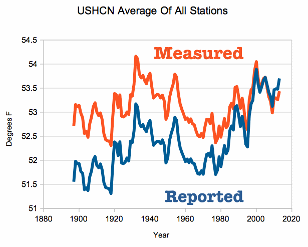
Hard for this old timer to believe a thing "called global warming" is nothing but "weather changes". I've seen it snow a few miles from the beach in Orange County, I have seen nonstop rain back up the Santa Ana river and flood into the streets, and I have seen drought conditions span over a year that produced "no measurable" rain.
The same shit happened 100 years ago, and probably another 100 years before that.
Nothing new here, move along, keep moving please, nothing to look at, move along please....while our government is busy cooking the books.
R
Robrites
California's drought divergence: Wetter in the north, still bone dry in the south
California's drought divergence: Wetter in the north, still bone dry in the south
When California water officials assess the drought, the first place they look is the northern Sierra Nevada mountains.
Rain and snowmelt from the area feed into a complex system of rivers, canals and reservoirs that send water across the state. And by almost all measures, the drought picture in Northern California has dramatically improved over the last two months, as a series of storms have helped replenish the state’s two major water projects. So far this season, rain levels in the northern Sierra are 180% of average, with 23.5 inches of rain falling — and more on the way this week.
But the story is more grim in Southern California, which remains historically dry. Now water officials must figure out how to deal with the disparity and its implications for managing the drought. While Southern California still gets some water from the Sierra, about 50% of its supply comes from local sources such as groundwater and reservoirs.
“California is a big place. It has different droughts in different parts,” said Jay Lund, a professor of civil and environmental engineering at UC Davis who studies water in California. “We certainly saw that last year … and we’re likely to see that again.”
Another big storm moving into California on Thursday is expected to dump large amounts of rain and snow in the north and considerably smaller amounts in Southern California.
Los Angeles marked a sober milestone earlier this year, when the National Weather Service announced that the last five years were the driest ever documented in downtown L.A. since official record keeping began almost 140 years ago. Precipitation during that period totaled just 38.79 inches — roughly half of normal.
Forecasters had predicted a wet 2016 fueled by El Niño, but the big storms never materialized. Federal climate scientists declared La Niña conditions last month, which they said will likely keep Southern California dry again this winter.
Northern California typically gets more rain than Southern California does, and the state’s water system is designed with that in mind; it moves water from the Sierra into cities and farms to the south.
But Lund said that even as conditions have gotten wetter, the state has struggled to move surplus water south across the delta. As a result, the benefits have been limited.
The sixth year of California’s drought could hardly have gotten off to a better start in Northern California. In October, when the water year began, the northern Sierra got more than four times its average amount of precipitation for the month.
As recently as last week, the northern Sierra got another 8 inches of precipitation, said Idamis Del Valle, a meteorologist with the National Weather Service office in Sacramento.
Forecasters say two more storm systems — the second of which will strike Los Angeles — will collectively dump as many as 9 additional inches of rain on the area by Friday.
“Here in Northern California, there has been some improvement,” Del Valle acknowledged.
The recent rains were enough to force federal officials to begin releasing water from Folsom Lake to protect against flooding for the first time since March, said Louis Moore, a spokesman for the Bureau of Reclamation, which manages the reservoir. Since the beginning of December, Folsom has risen more than 20 feet — an increase of about 55 billion gallons.
As of last week, the U.S. Drought Monitor reported that drought conditions no longer apply to about 27% of California; it should come as no surprise that all the areas where the drought has relented are located in the upper reaches of the state.
Meanwhile, a vast swath of Southern and Central California — from Orange County to Tulare County — remains mired in “exceptional” drought conditions, according to federal officials.
The so-called Key Well, which measures groundwater levels in the San Gabriel Basin, hit a historic low in October. Meanwhile, Lake Perris in Riverside County is holding less than half the amount of water it usually does at this time of year. Castaic Lake in Los Angeles County is faring only marginally better, filled to only 74% of its normal levels.
Along the Central Coast, Lake Cachuma is filled to only about 7% of its capacity, which has prompted Santa Barbara city officials to impose a ban on lawn watering, effective next year. Further inland, the Tulare Basin has received only about four inches of rain so far this water year — about 64% of average.
read more
HazyBulldog
Member
Seem like more and more weather channels are becoming political, and their predictions are becoming less and less reliable.
They claim so cal is only 64% of it's normal rain fall. Normally receives 7 inches of rain. Well, Nor cal is 180% over and normally receives over 20". Seems like we are in a net plus to me......
They claim so cal is only 64% of it's normal rain fall. Normally receives 7 inches of rain. Well, Nor cal is 180% over and normally receives over 20". Seems like we are in a net plus to me......
A weekend rainstorm that drenched Southern California and triggered hundreds of freeway crashes will disappear by the afternoon and make way for cool, autumn weather on Thanksgiving, the National Weather Service said Monday.
Over Sunday and Monday, the storm dumped more than two inches of rain in San Luis Obispo County and more than an inch at Brentwood’s Getty Center in Los Angeles County, where a surge in car crashes left freeways intermittently jammed, authorities said.
According to statistics from the California Highway Patrol, between 9 p.m. Sunday and 1 a.m. Monday there were 201 reported crashes on L.A. County’s freeways — a 570% increase from the same period last week when the CHP counted 30 crashes.
Runoff also swelled the Los Angeles River and prompted the rescue of four people who were stranded on a small island near Atwater Village early Monday morning, officials said.
About 100 Los Angeles city firefighters worked to rescue the two men and two women who had climbed into trees as rising water swept past at 35 mph. The city had activated two rescue crews the night before, said Los Angeles Fire Department spokesman Erik Scott.
Another Los Angeles River rescue occurred in South Gate, where Los Angeles County firefighters rescued a man who tried to walk through the fast-moving water Sunday night, officials said.
By Monday afternoon, the storm should make way for patchy clouds and temperatures in the mid-60s, said National Weather Service meteorologist David Sweet.
“I think our rain is pretty much over for the rest of the week,” he said.
Inland valleys could reach the mid-70s by Thursday, but the rest of Southern California’s beach and mountain communities and downtown L.A. should be a few degrees cooler through the rest of the week, Sweet said.
Northern California is also being hit by rain this week, which is producing much-needed snow in the parts of the Sierra Nevada mountains, a key source of water for California as the state deals with a fifth year of drought.
http://www.latimes.com/local/lanow/...ry.html?utm_source=dlvr.it&utm_medium=twitter
What the fuck? 200 car crashes in one night and people got stranded and needed to be rescued in 2 inches of rain?
I mean MAYBE if it really did just all fucking clop down at once like a tidal wave and people are driving some RWD bullshit with racecar tires...
IDK man. I think we should just let SoCal secede from the Union...
R
Robrites
Nah, man, I don't think it was like that. It may have been that there was a lot of oil build-up on the roads do t6o the lack of moisture and the rain turned it super slippery. Plus, also, as you were saying, there are a lot of fucki9ng idiots in California. (and 27 groovy weed growers).What the fuck? 200 car crashes in one night and people got stranded and needed to be rescued in 2 inches of rain?
I mean MAYBE if it really did just all fucking clop down at once like a tidal wave and people are driving some RWD bullshit with racecar tires...
IDK man. I think we should just let SoCal secede from the Union...
Nah, man, I don't think it was like that. It may have been that there was a lot of oil build-up on the roads do t6o the lack of moisture and the rain turned it super slippery. Plus, also, as you were saying, there are a lot of fucki9ng idiots in California. (and 27 groovy weed growers).
As I recall southern California roads, freeways especially, were always a hazard even if only a little rain fell. Oil slicked I guess plus people there just don't know how to drive on wet roads.
That sounds right. I remember learning that in super dry areas when it does finally rain all the oil that's receded deep into the asphalt rises to the surface and even after the rain is done the roads are still super slick.
But where I grew up we got plenty of precipitation and anybody without AWD is a commie.
Ahhh that "liquid sunshine" was greatly appreciated.
Yep, with no rain the roads act like sponges--sucking up all the oil, dirt, dust and what not--and when you add water (first rain) all that muck turns into a slip-n-slide slurry that most people underestimate.
Worse yet, is all this mucky shit flows into the gutter, down the storm drain and into the ocean. Which means the ocean coast, for the next couple of days, will be full of "nasties".
R
Robrites
R
Robrites
L.A.'s wettest month in years will continue through to New Year's Eve
L.A.'s wettest month in years will continue through to New Year's Eve
Los Angeles County could see between a quarter-inch and half-inch of rain Friday as the first of two anticipated storm systems passes through the region this weekend, according to the National Weather Service.
The rainfall will add to what is already the wettest month recorded in downtown Los Angeles since December 2010, said David Sweet, a weather service meteorologist. So far this month, the area has seen 4 inches of rain, nearly double the historical average for December.
On Friday, there’s an 80% chance of rain forecast at 4 a.m., with a possibility of showers returning Friday night, Sweet said.
On Saturday afternoon, a second storm system coming from the northwest is expected to pass through, bringing a 40% chance of showers into the evening.
Temperatures will fall to about 65 degrees on Friday and 50 to 60 degrees on Saturday, Sweet said.
Snow levels could drop to about 4,000 feet in the foothills of the Antelope Valley, according to forecasts.
The weather service also warned of possible wintry driving conditions Saturday along the Grapevine area of the 5 Freeway and the Cajon Pass area of the 15 Freeway.
Last week, some areas of Los Angeles saw as much as 2 inches of rain, according to the weather service. The storms contributed to nightmarish conditions at Los Angeles International Airport, where bad weather, crowded airspace, security scares and construction caused some flights to be delayed or rerouted. The rain also caused the usual road congestion and accidents.
In an area that has been hit hard by five years of severe drought, the wet winter has been a welcome development.
Steady, moderate rain over weeks and months this year is what has pulled 15% of the state — all of it up north — out of drought conditions, according to the weather service and the U.S. Drought Report. The rains have helped recharge reservoirs that feed the two massive systems that move water from the northern Sierra to the state’s cities and farmlands.
R
Robrites
After six years of drought, this is the winter weather we're 'supposed to be getting,
After six years of drought, this is the winter weather we're 'supposed to be getting,
The slow but steady improvement in California’s drought picture should accelerate in the new year with a series of storms that are expected to dump rain and snow in Northern California.
The northern half of the state has already seen impressive rains this fall and winter, filling reservoirs and replenishing the Sierra snowpack, a key source of water for California cities and farmlands.
A storm system is expected to bring rain and snow throughout the week in Northern California, and a foot of snow is expected Tuesday in the Sierra Nevada and another foot or two is predicted for Wednesday, said Johnnie Powell, a weather forecaster with the National Weather Service.
“This is what we’re supposed to be getting,” Powell said. “After six years of a drought, I love saying that. This is normal rain and snow that we’re supposed to be getting in December and January.”
That same system might bring much-needed moisture to Southern California by the middle of the week. But that’s just a precursor to a bigger storm, NWS meteorologist Joe Sirard said.
The main event, a stronger storm system, is expected to move into the Los Angeles County area late Saturday and continue until Monday.
“There is the potential that if the main moisture feed into Southern California lines up over Ventura and L.A. counties, we could be under the gun for many inches of rain,” Sirard said.
Steady rain since the fall has pulled 15% of the state — all of it up north — out of drought conditions, according to the National Weather Service and the U.S. Drought Report.
But while Northern California has begun to rebound from the drought, Southern California remains dry.
Los Angeles marked a sober milestone last year, when the NWS announced that the last five years were the driest ever documented in downtown L.A. since official record-keeping began almost 140 years ago. Precipitation during that period totaled just 38.79 inches — roughly half of the normal amount.
But December turned out to be a boon for Southern California, with a series of storms dumping decent amounts of rain and snow. It ended up being the wettest December since 2010.
State officials have said it’s far too early to declare the six-year drought over, though they acknowledge the improvements in Northern California.
In late December, officials said the Sierra Nevada snowpack was at 72% of normal. They expect that number to increase in the coming weeks.
Northern California’s improving fortunes help Southern California’s drought picture — but only to a point. Though Southern California still gets some water from the Sierra, about 50% of its supply comes from local sources such as groundwater and reservoirs.
December’s conditions and cold temperatures across the state have provided a winter wonderland view in both Southern California and the Bay Area, with mountain peaks getting strong dustings of snow.
The Grapevine was closed for periods in recent weeks because of heavy snowfall, and some motorists were temporarily stranded on mountain roads.
Loving the rain here in so cal, folks wells are coming back...
I know this is a link but its ok and its probably the best info you will get I've watched this video literally like 5 times and I'll watch it again today. This man is a wizard! He will explain the PDO to you. If has been posted before sorry well it deserves a repost because even I don't entirely get it and its a video to watch multiple times!
Drought in or out?
https://www.youtube.com/watch?v=BGosqRfMTMM&t=4062s
Drought in or out?
https://www.youtube.com/watch?v=BGosqRfMTMM&t=4062s
R
Robrites
Mammoth mega-storm expected to drop up to 20 feet; 'God help us'
Mammoth mega-storm expected to drop up to 20 feet; 'God help us'
Another blizzard swept Mammoth Mountain on Wednesday, the precursor to a string of storms expected to bring up to 20 feet of fresh snow in the next 10 days, the resort says.
Since Tuesday, 26 to 48 inches of fresh snow had fallen, with the deepest totals at the summit. Plows were working furiously to keep lots and streets clear.
Normal resort operations could be affected as personnel struggle to deal with the snow.
The cause of the snow? One of those “atmospheric rivers” that forecasters refer to in particularly generous storms like this. In the next week and a half, the Sierra resort is expecting three of those wet cycles.
It is shaping up as the second epic season in a row for the big resort five hours north of Los Angeles.
“They say we could get up to 20 feet,” said Mammoth Lakes resident Cynthia Hayes. “God help us.”
Locals were waiting out the storm while anticipating great skiing on a mountain of fresh powder.
Farther north, Lake Tahoe resorts were digging out from the same system. This latest storm dropped more than 2 feet, and the forecast is calling for more than 4 feet of snow through Thursday.
Closer to home, resorts in and near the San Bernardino Mountains were awaiting the same weather system, while hoping temperatures dipped enough to turn rain into snow.

