What's new
  • Happy Birthday ICMag! Been 20 years since Gypsy Nirvana created the forum! We are celebrating with a 4/20 Giveaway and by launching a new Patreon tier called "420club". You can read more here.
  • Important notice: ICMag's T.O.U. has been updated. Please review it here. For your convenience, it is also available in the main forum menu, under 'Quick Links"!

This is the biggest El Niño on record, and a killer La Niña is coming

R

Robrites

New Research Shows How 'Atmospheric Rivers' Wreak Havoc Around The Globe

New Research Shows How 'Atmospheric Rivers' Wreak Havoc Around The Globe

An "atmospheric river" is a colorful term for a sinuous plume of moisture that travels up from the tropics — a single plume can carry more water than the Mississippi River at its mouth. But new research shows that atmospheric rivers are also among the most damaging weather systems around.

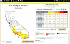
The atmospheric rivers that soaked California this winter did some good — they ended an epic drought in the state.

"This has been a very active winter, atmospheric river-wise," reports Jeff Zimmerman of the National Weather Service. "We've probably had 10 or more ... this winter." The norm is just a few; being a La Nina year, with cooler water in the eastern Pacific, was part of the reason for the abundance.

Atmospheric rivers are famously wet. But atmospheric scientist Duane Waliser has done some new research that shows they're also remarkably windy.

Waliser studied two decades of storms around the globe at mid-latitudes — that is, outside the tropics. When he focused on the very windiest — the top 2 percent — he found that "atmospheric rivers are typically associated with 30 and even up to 50 percent of those very extreme cases." Atmospheric rivers were also responsible for almost that percentage of the very wettest storms, too.

But the windiness was surprising. Waliser found that winds during an atmospheric river are typically twice the speed of the average storm. He says emergency responders need to know that.

"Not only do [atmospheric rivers] come with this potential for flooding hazards," he says, "they also come with potential for high impact winds and extremes that can produce hazardous conditions."

In fact, the atmospheric river that hit California on Jan. 8 knocked over a famous — and gigantic — sequoia in a state park.

Waliser, who's with NASA's Jet Propulsion Lab in California, says the combination of water and high wind is especially costly. Over the past two decades, for example, Europe experienced 19 storms that each did at least a billion dollars in damage. "And so out of these 19 storms," he says, "we associated atmospheric rivers with 14 out of the 19."

Waliser's research appears in the journal Nature Geoscience. He says his next project is to find out if climate change will make atmospheric rivers more frequent.
http://www.npr.org/sections/thetwo-way/2017/02/20/515838078/new-research-shows-how-atmospheric-rivers-wreak-havoc-around-the-globe
 
R

Robrites

Portland, Oregon is on track to set a record for the most rain ever in February.
 

DocTim420

The Doctor is OUT and has moved on...
I bet some of those mountain pass roads that are closed now for the winter...will stay closed until July 4th. And, many of the usual trout fishing destinations will NOT be snow free on opening day (last Saturday in April).

Many years ago while camping in the boonies (the only way to go), there was still snow on the ground mid June and catching your limit in a few hours was the "norm". Ahhh...fresh trout, breaded and pan fried in butter sprinkled with almonds--can almost taste it now, lol.
 

cravin morehead

Active member
Veteran
hey Doc- i love fishing the alpine lakes up in the Sierra's. you are right, fresh pan fried trout in the middle of nowhere is about as good as it gets in my book.

cm
 
R

Robrites

Evacuation ordered as levee breaks in Northern California

Evacuation ordered as levee breaks in Northern California

Feb. 21 (UPI) -- A levee broke in Northern California after severe rainstorms, leading authorities to order more than 500 people to leave their homes Monday night.

The breach was discovered in a levee near the town of Manteca in San Joaquin County, south of Stockton. It was repaired, and the state's Office of Emergency Services described it as "stable," but the evacuation orders remain in place.

Most of the people ordered to evacuate reside on farms and ranches.

The breach, on the east side of the San Joaquin River, was repaired after the evacuation orders were issued. Manteca resident Dino Warda said local farmers, with tractors and excavators, helped state employees shore up the levee. The break in the levee came south of Highway 120 and west of Manteca Road, two miles west of Airport Way and Perrin road, the Sacramento Bee reported.

"Work crews have made impressive progress on filling in the levee gap, and reducing the flow of water. Crews will stay on the scene to further stabilize the levee to completely seal the opening," the OES statement said in part.

An evacuation center in Manteca was established on Monday for those who left their property, and a Sikh temple in Stockton also offered shelter. The National Weather Service issued a flash flood watch in the area, due to the levee break.

http://www.upi.com/Top_News/US/2017/02/21/Evacuation-ordered-as-levee-breaks-in-Northern-California/8021487684833/
 
R

Robrites

Thousands flee rising floodwaters in San Jose as mandatory evacuation orders are wide

Thousands flee rising floodwaters in San Jose as mandatory evacuation orders are wide

Thousands flee rising floodwaters in San Jose as mandatory evacuation orders are widened

San Jose was hit by what officials described as the worst flooding in 100 years as the Coyote Creek, which runs through the heart of Silicon Valley, overflowed, inundating neighborhoods and forcing thousands to evacuate.

The evacuations covered a large swath of central San Jose and involved an area where an estimated 14,000 people live. Flooding closed the 101 Freeway — a key route through Silicon Valley — as well as other major roads.

On Tuesday evening, the creek crested to a height of 13.6 feet at a river gauge point in South San Jose — nearly 4 feet above flood stage. The record before then was in 1922, when the creek crested at 12.8 feet, and before that, in 1917, when the creek reached 12.2 feet.

“This is a once-in-a-100-year flood event,” National Weather Service meteorologist Roger Gass said, referring to Coyote Creek’s surging height in South San Jose. “This is a record level.”

The mandatory evacuation zone covered a large swath of central San Jose, from just east of San Jose State University and two miles east of Mineta San Jose International Airport, according to a tweet issued by the mayor. At its widest point, the mandatory evacuation area covers a zone roughly 1½ miles long and one mile wide.

A larger voluntary evacuation advisory zone covered a roughly seven-mile stretch of Coyote Creek, a region that went northward from Interstate 280 northward, beyond U.S. 101, Interstate 880, and all the way to Highway 237 near San Francisco Bay.

“There’s going to be a lot of time for ‘Monday morning quarterbacking’ in the next few days. I think right now we’re just really focused on getting folks out of neighborhoods that are in peril,” San Jose Mayor Sam Liccardo told reporters Tuesday. “Any time we’re showing up in boats to get people out of their homes, there’s been a failure. Clearly we fell short if the first time folks are hearing about having to get out of their home is when we’re showing up in a boat.”

The culprit was another round of heavy rain in recent days that finally tipped Santa Clara County’s largest reservoir to overflow, the first time it had done so since 2006. Anderson Reservoir, which is constrained by the 67-year-old Anderson Dam, is about 15 miles southeast of the first San Jose neighborhood that saw widespread damaging floodwaters Tuesday.

The reservoir became full Saturday morning, and it wasn’t until a downpour Sunday night and Monday morning that water began flowing over its wall and into Coyote Creek.

Anderson Reservoir had been releasing as much water as possible through its main outlet since Jan. 9.

“But, with the many wet storms that have occurred one after another, the rate of flow into the reservoir has at times exceeded the rate of water we are releasing from the outlet,” said a statement by the Santa Clara Valley Water District.
 
R

Robrites

The verdict after all that rain? Most of California is out of the drought

The verdict after all that rain? Most of California is out of the drought

picture.php
 
R

Robrites

Shasta Dam makes history as water flows from top gates for first time in 20 years

Shasta Dam makes history as water flows from top gates for first time in 20 years

While California’s other major dam has been the focus of national attention, the Shasta Dam was making history itself this week.

For the first time in almost two decades, water was released Wednesday from the topmost gates of the dam impounding Lake Shasta, California's largest reservoir, marking another milestone in what is shaping up to be the state's wettest year on record.

The release lasted just 15 minutes and was only a test to confirm that the gates were functioning properly in case they need to be used at a later time, according to the U.S. Bureau of Reclamation. The gates operated as expected, bureau spokesman Louis Moore said.

With the reservoir at 135% of its historical average for this time of year and nearly 93% of its capacity, dam engineers were releasing billions of gallons of water to make room for incoming flows from the surrounding foothills and Sierra Nevada, according to the bureau.

Water was flowing from the reservoir at up to 70,000 cubic feet per second into the Sacramento River, and communities downstream were preparing for a corresponding surge along its banks.

Shasta Dam is the linchpin of California’s federal water project, which sends water down to cities and farms to the south. Oroville Dam is the heart of a separate state water project, which also moves water from the Sierra Nevada south.

Oroville was at the center of a major crisis when an emergency spillway showed signs of failing, prompting the evacuation of more than 100,000 residents downstream. Since then, officials have lowered water levels at Lake Oroville and the concerns have eased.

There have been no issues with the spillways at the Shasta Dam, though officials downstream have been talking about contingencies in the unlikely event that significantly more water needs to be released from it.

This week marked the first time the agency has used the gates at the top of the 602-foot-tall dam about 120 miles from the Oregon border in far Northern California since the state’s last huge rainy season in 1997-98.
 
R

Robrites

Sierra Snowpack Smacks California's Drought

Sierra Snowpack Smacks California's Drought

Remember those pictures of parched lawns and bone-dry unplanted fields when it seemed that Californians could only pray for rain and snow?

Now thanks to one of the wettest winters on record, scientists say that the snowpack along the Sierra Nevada mountain range is a whopping 185 percent of average. And that's important because the runoff from the Sierra snowpack provides one-third of all of California's water.

NPR's Kirk Siegler was up in the mountains Wednesday near the Sierra-at-Tahoe ski resort, at about 7,000 feet near Lake Tahoe, where surveyors traditionally take their measurements. As he told All Things Considered, "I've been here around this time of year for this for past three years, one year NO snow, last year, some and this year it's staggering."


Siegler watched as Frank Gerhke, the state's chief snow surveyor, took his reading with the help of a long cylindrical gauge.

"Gehrke and his team take manual measurements here and combine it with electronic data from monitoring sites across High Sierra and they hand that over to reservoir operators and farms and cities downstream in the form of a forecast to know just how much water they'll get out of this snow in coming months," said Siegler.

But California's five year drought hasn't been declared officially over yet. The snowpack will be measured again in April when the snowpack is usually considered to peak. Gov. Jerry Brown has said he'll wait for that measurement before making a call on the drought and the water conservation measures that were implemented as a result of the dry years.

All of the snow and rain have created other problems. State reservoirs are at capacity. Problems at the Oroville dam caused officials to evacuate nearly 200,000 people for fear that an emergency spillway would fail. Damage from flooding in other parts of the state will cost $1 billion, according to state officials cited by the Associated Press.

And winter isn't over yet, said Siegler.

"A big question is what's going to happen when all this snow melts, and if we were to get a big warming trend all at once, that's a lot more water and run off coming down," he said.
http://www.npr.org/sections/thetwo-way/2017/03/01/518042343/sierra-snowpack-smacks-california-s-drought
 
T

TrueReligion

74.49% of California is out of drought
 

Attachments

  • Screenshot_2017-03-04-23-38-36.jpg
    Screenshot_2017-03-04-23-38-36.jpg
    54.6 KB · Views: 14
R

Robrites

From 122 degrees in Death Valley to 100 in Sacramento, heat wave to plague California

From 122 degrees in Death Valley to 100 in Sacramento, heat wave to plague California

Sweltering heat will plague much of California this week and increase snowmelt along the Sierra Nevada, forecasters said.
Starting Thursday, a heat wave will grip the mountains, deserts, valleys and major cities for several days as temperatures soar into the 90s and 100s.
Because temperatures will be 15 degrees above normal across the state, forecasters urged Californians to stay indoors and keep cool to prevent any heat-related illnesses.
So far, the warm weather hasn’t triggered any heat advisories or warnings.
On Monday, a late-season storm dropped snow flurries in Truckee and the Lake Tahoe area. But by the end of this week, temperatures were expected to jump 40 degrees and swing into the 80s, forecasters said.
The warmer weather will also increase snowmelt and likely cause flows to surge in creeks, rivers and streams, according to meteorologist Dawn Johnson of the weather service’s office in Reno.
“Of greatest concern is the Walker River Basin and streams originating in the high terrain of Mono County, where plenty of high-elevation snowpack remains,” she said in a forecast statement. “For those living along waterways, keep all flood mitigation measures in place and for those with recreation plans in the back country next weekend, prepare accordingly.”
Showers and thunderstorms may move over the Sierra Nevada on Sunday and Monday, forecasters said.
In the San Francisco Bay Area, a high-pressure system will force temperatures to soar into the 90s.


Temperatures in Northern California for Friday and Saturday

  • Sacramento: 100 degrees Friday
  • Redding: 98 degrees Friday
  • Fairfield: 96 degrees Friday
  • San Rafael: 95 degrees Saturday
  • Santa Rosa: 98 degrees Saturday
  • Napa: 97 degrees Saturday
  • Livermore: 100 degrees Saturday
  • Merced: 101 degrees Saturday
 
R

Robrites

Southwest US preps for 120 temps: Water, water, more water

Southwest US preps for 120 temps: Water, water, more water

LOS ANGELES (AP) — When bracing for 120 degrees, it’s all about the water.
Drinking it, splashing in it to stay cool, and drinking it some more. A lot more.
That’s what officials were urging and residents were planning Friday as a potentially record-shattering heat wave started enveloping the Southwest United States and threatened to bring temperatures of more than 120 degrees to parts of Arizona and California next week.
People in places like Palm Springs and Phoenix are used to seriously high temperatures, but 120 degrees becomes all the talk around the water cooler. And with the health dangers of heat and dehydration, that’s where authorities hope they keep coming back.
Teresa Flores in Phoenix said she will make sure her two sons and daughter stay hydrated.
“Water, water, water, water,” Flores said. “So even when they think they’re not thirsty, they’re drinking water.”
Jennifer Vollmann brought her 2-year-old daughter to a public pool in downtown Phoenix, where the temperature hit 108 Thursday. With 121 degrees predicted Tuesday, “we’ll be here, she’ll be in the pool,” Vollmann said as her daughter ate a blue ice pop.
Strong high pressure building over Western states is bringing the hot onslaught.
Officials warned of excessive heat across southern portions of Arizona and Nevada, and throughout the 450-mile length of California’s Central Valley. Almost the entire Golden State was predicted to simmer above normal temperatures, easing just short of the coast.
With up to 122 on the horizon, Palm Springs will have cooling centers in community centers and libraries, and Phoenix and nonprofit groups are planning water stations to help the homeless and others.
Palm Springs has soared above 120 several times, most recently hitting 122 on June 29, 2013.
The National Weather Service in Phoenix said the last time the temperature topped 120 was 1995, at 121. The record high is 122 degrees, set on June 26, 1990.
In the Arizona desert near the U.S.-Mexico border, the heat can be so deadly that the Border Patrol reassigns agents and resources to areas that are especially dangerous for immigrants.
“It is physically impossible for the average person to carry enough water to survive several days of walking through the desert,” the agency said in a statement.
The area saw more than 1,400 rescues and 84 deaths last fiscal year, according to statistics provided by the agency. Through April, agents in the Tucson Sector have rescued 160 people and reported 14 deaths.
Las Vegas and nearby cities also are preparing for the first heat wave of the season with extra cooling stations. Tuesday’s high was expected to hit 115.
With the three-day outdoor Electric Daisy Carnival music festival kicking off Friday, organizers used social media to encourage attendees to stay hydrated. It was providing free water during the nighttime event, which has drawn more than 130,000 people in past years.
In California, forecasters said prolonged heat would make snow melt faster in the Sierra Nevada, where massive winter storms coated towering peaks after years of drought. Waterways could flood, with vacationers warned to be cautious near water and avoid camping close to streams.
Camp counselor Sabrina Chu, 17, said she and others in San Francisco were having kids drink lots of water while playing outdoors. The city was expected to have a high of 82 Sunday, well above the normal upper 60s.
“Compared to other places in California, the Bay has pretty consistent weather, so this is unusually hot for the area,” Chu said.
In Southern California, inland valleys, mountains and deserts would likely bear the brunt of the heat wave. Cities such as Redlands and Fontana east of Los Angeles planned to use community facilities as cooling centers.
Back at the pool in Phoenix, Vollmann sounded a note of optimism about temperatures “cooling down.”
“It’ll be 110 soon,” she said.
 

DocTim420

The Doctor is OUT and has moved on...
Southern California's heat wave expected to break records Friday

Southern California's heat wave expected to break records Friday

Source: http://www.latimes.com/local/lanow/la-me-ln-heat-wave-southland-20170705-story.html
A heat wave settling over Southern California this week could break records from the coast to the mountains while the potential for thunderstorms may increase the risk of dry lightning sparking a fast-growing wildfire, the National Weather Service said Wednesday.

The heat wave is expected to peak between Friday and Saturday, when it could approach 120 degrees in the Coachella Valley and 112 in Woodland Hills, forecasters said. Burbank, its neighboring cities and communities on either side of the San Bernardino Mountains can also expect to bake in triple-digit heat from Thursday through the weekend, said Stuart Seto, a National Weather Service specialist.

“This is really dangerous heat. People need to be taking extreme precautions,” Seto said.

Seto added that the National Weather Service’s temperature measurements are taken in the shade, meaning that it will be even hotter in direct sunlight.

he scorching weather is part of a system commonly referred to as the “Four Corners high,” a high-pressure system that settles over the desert Southwest near the Four Corners and spreads smothering heat from California to Nevada and as far east as central Texas. The Four Corners is the area where Arizona, Utah, New Mexico and Colorado meet.

The heat wave will broil communities from San Luis Obispo County to the Santa Monica Mountains and reach inland, where thunderstorms over the San Bernardino Mountains could bring dry lightning strikes and fire.

“Sundowner” winds unique to the Coast Range could push any small blaze deep into unpassable, rugged terrain around San Luis Obispo and Santa Barbara counties, Seto said.

Monsoonal moisture moving up from Mexico will add humidity to the mix, making the conditions even more miserable and preventing the region from significantly cooling overnight, Seto said.

Though parts of Los Angeles were under a heat advisory Wednesday, the mercury will really begin to rise closer to the weekend, Seto said.

Oh joy! Although I live about 5-6 miles from the ocean, I know it will be over 100 in my backyard. LOL...nakedness around this time of the year is...well, cool.
 

EasyGoing

Member
http://www.theblaze.com/news/2017/0...-the-claim-humans-are-causing-global-warming/

A new peer-reviewed study by scientists and a statistician claims to reveal that “nearly all” of the warming shown in current temperature datasets from NASA, the National Oceanic and Atmospheric Administration and the Met Office in the United Kingdom are the result of adjustments made to the datasets after temperatures were recorded, calling into question just how much warming is real and how much is pure fantasy.

In the report, titled “On the Validity of NOAA, NASA and Hadley CRU Global Average Surface Temperature Data and the Validity of EPA’s CO2 Endangerment Finding,” authors James P. Wallace III, Joseph S. D’Aleo and Craig Idso examine the accuracy of global average surface temperature data.

“The objective of this research was to test the hypothesis that Global Average Surface Temperature (GAST) data, produced by NOAA, NASA, and HADLEY, are sufficiently credible estimates of global average temperatures such that they can be relied upon for climate modeling and policy analysis purposes,” the authors wrote.

More story, follow the link.
 
Top