What's new

THE HYPERBOREA PROJECT

A

arcticsun

heheh no offense taken lmt the language comes from the fisherman culture, its quite expressive idd


Here are some pictures from some random sites along my way, i didnt find time for any sight seeing really, i just had to stop and snap a pic once in a while from the car mostly. And when i wasnt driving efficiently i was stuck without a car. I did go for a mountain hike when the car broke down the first time, when the waterpump failed.


This happened in a place called "Gudvang" on the west coast of Norway about 4 hours from Bergen.. vang means meeting place and Gud is .. well God.. So the car broke down on the meeting place of the Gods :D I learned from the locals while i was there that it was a hotspot for viking activity back in the day. The area is known as "Aurland" which means "troutland" directly translated to English. There are several high class trout rivers in the area. Unfortunately the season hadnt started for the seatrout in the rivers in this region yet so I was left to enjoying the scenery.


I was there for 2 days, spent one night at a fishing camp by the aurland river.. the troutland river if you will :D Here are some pictures from Aurland (troutland).


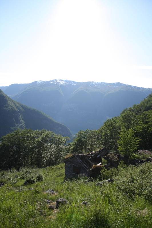
My accomodations the first day, i had the hut at the far left of the pic. It was 45 Euros, shared bathroom/shower with the other huts, room for 4, two bunkbeds. Hotplate, Tv with one channel, the communist Norwegian, DDR-like, govt propaganda mashine known as NRK which belches reruns of old drama shows from the 80s at the viewers along with politically "rounded" debate programs and evening shows that seemingly has no theme and no informational value whatsoever...

picture.php


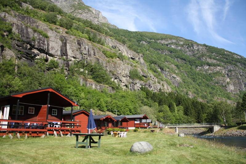
Whats on the one channel you may ask? Naturally its "Derrick".. German crime show from the 80s starring Horst Tappert as Derrick with sidekick Harry Klein. This show has been run on the govt channel more then the daily news tbfh. Fucking Derrick.. lmao.. anyway thats what was on the TV :D

picture.php


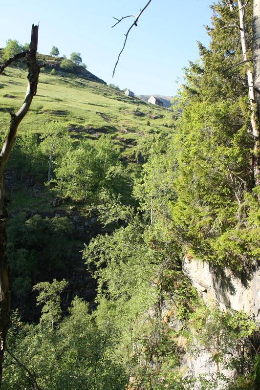
Fuck TV anyway, i blazed up a couple of fatties .. i was sorry that the river hadnt opened. Decided to go for a hike up the mountainside along the waterfall that was overhead. Every valley in Norway has one or more of these waterfalls, its just a random one :D Was a nice nature trail to the top, the mountainsides was thick with vegetation, wild flowers and berries all along the trail.


picture.php

picture.php


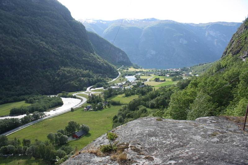
Moving up the trail there were different viewpoints where i could look out towards the fjord and the river below, it was hard to capture the perspective of the whole scenery in a 2D picture frame. First viewpoint was some rock boulders that stuck out from the vegetation, im abit too scared of heights to go all the way out on the tip of the rock to take a picture of the drop below, but it was about a 150 to 200 meter drop i reccon. Here is looking down the valley towards the fjord.

picture.php


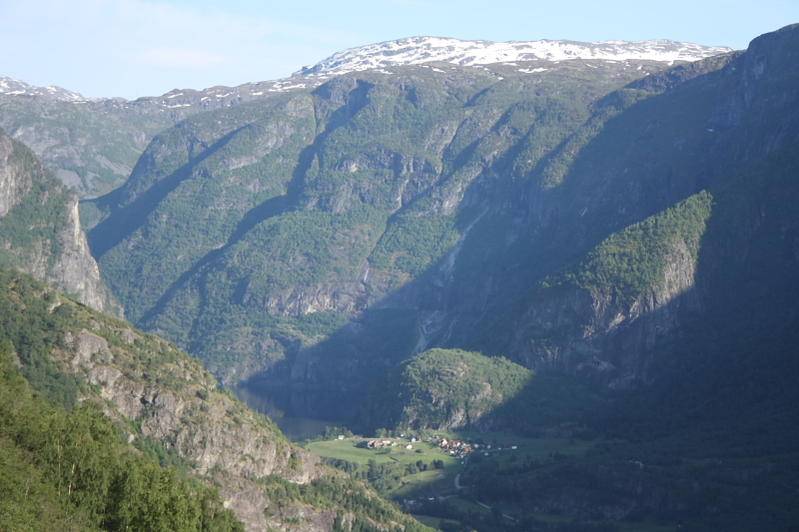
Here im alittle higher still and looking up the Aurland valley.

picture.php


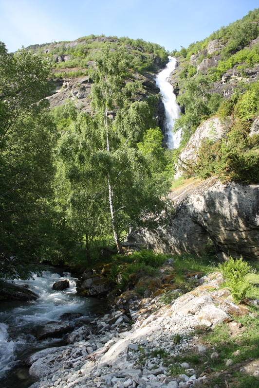
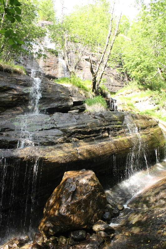
It was hot that day, and the trail was very steep. Hidden in the vegetation on my way up was smaller rivers and waterfalls trickling down the mountainside. I got very sweaty and hot on the way up, halfway up i found this waterfall where i took a nature shower. It was fantastic, the water was cool but not too cold. Real delightful experience..

picture.php


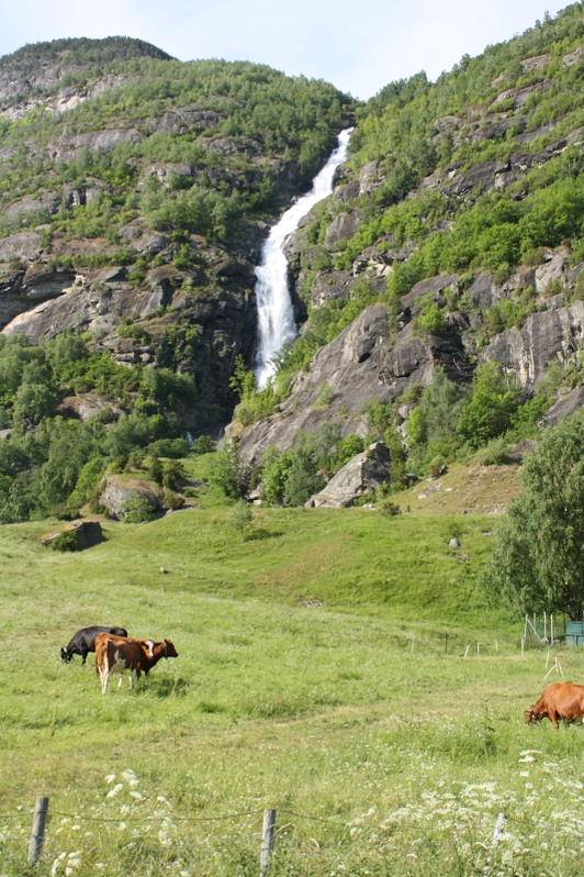
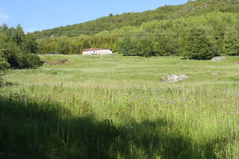
Even further up the mountain I got to the grazelands of sheep, these are rapidly deteriorating these days due to the communist style centration farming politics run by the fully red govt. These days small farms are shut down in favor of massive industrial scale facilities. This old culture landscape with old grazelands and shepherds huts high up in the mountainsides is rapidly getting overgrown. In the old days, especially in the viking days there would have been plenty of hemp grown hereabouts.

picture.php

picture.php

picture.php


This is where i turned, this was at the top of the waterfalls. I had left the trail to go see if i could find a viewpoint but the vegetation was to tight and the slope was too steep. Kind of dangerous. There were still more meadows further up the mountain. This one was still in use with sheep grazing, i think the elevation could have been between 600 and 800 meters from where i turned, the vegetation was just starting to become alittle less dense. But it was still below the treeline. That meadow and shepherds hut overhead must have been another 100 meters higher i guess.. its very steep, it does not really show in the pictures how steep these mountainsides are, they are almost vertical with many cliffdrops of several hundred meters as one moves up. From where this pic is taken there was a steep drop below, ca a 75-80 degree drop of 50 meters maybe down into the top of the waterfalls, the slope was very slippery and i was holding on to trees to avoid sliding down the hill into the river. The vegetation was too dense to get a proper picture showing the top of the waterfalls and the valley below. The picture is taken lookin up the mountainside at approx 600 to 800 meters elevation.

picture.php


..meh.. the pictures did not do the scenery any justice tbh..


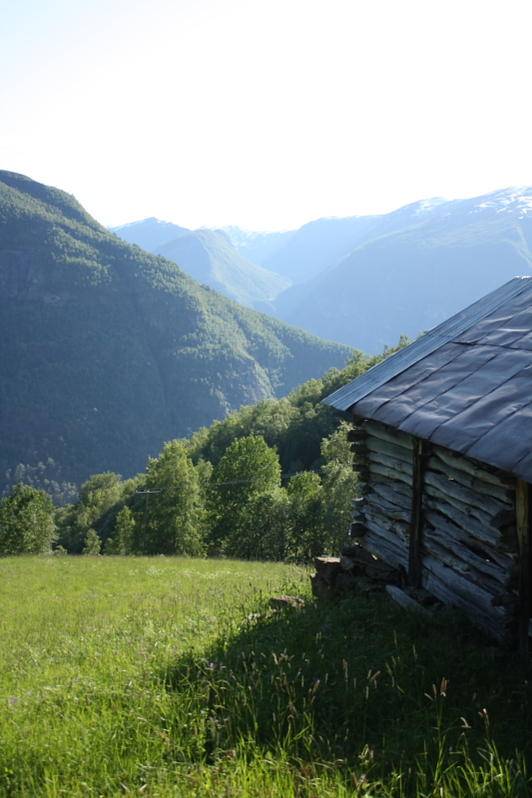
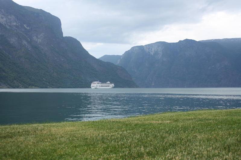
Anyway, the next day i decided to pitch the tent by the fjord close to the carshop. Here is the view from my tent..


picture.php

picture.php


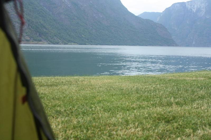
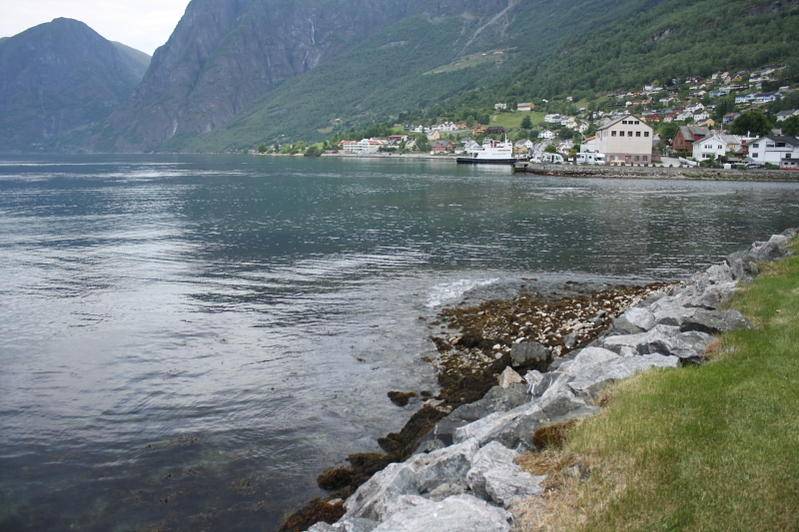
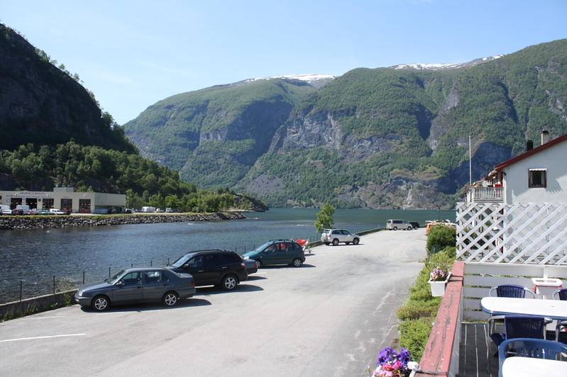
the town.. Aurland.. not a big place as you see, the local cafe served good food at a good price.

picture.php


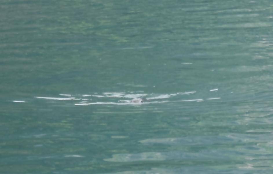
I had company by this seal which was hunting for fish by the mouth of the Aurland river just outside my tent, i had a nice relaxing time watching the seal and smoking some doobs that night.. Damn hard to capture a sea animal on camera btw, sorry if you cant see properly, but its a type of seal known as a "kobbe" in the local tongue. Its not technically a seal i guess.

picture.php


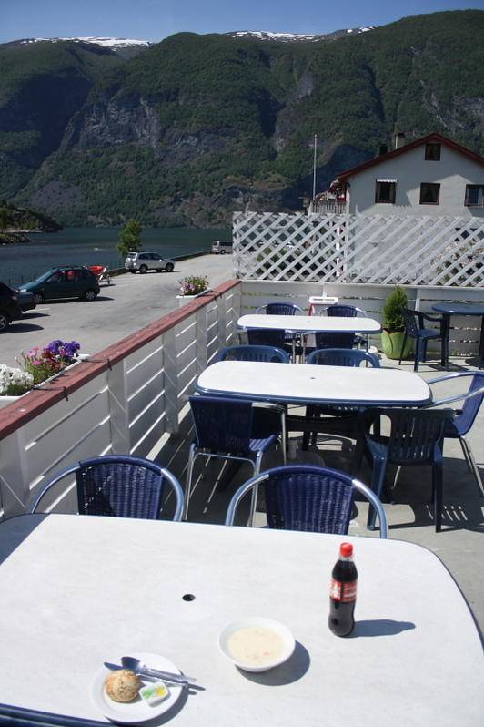
The food was good and affordable at the local cafe as i mentioned. The "creamy Norwegian fish soup" ;) :D is famously the best fish soup in the world.. The cafe was on a nice spot by the Aurland river outlet. You can see the autoshop on the other side of the river, its the big white building, i pitched my tent on the molo on that side of the river behind that building on a grass field.


picture.php

picture.php
 
Last edited:
A

arcticsun

Creamy norwegian fish soup was 5 euros with a bread bun on the side, special ingredient included :D


After Aurdal, i was on the road for about 4 hours before the kardang broke, which was this past Friday after the shops had closed ofc.. So i had to take accomodation at a place called Oppdal, it cost me a bit, had to stay 4 nights over the weekend until tuesday to get the part needed for the fix. I was in no mood for sightseeing or picture taking in Oppdal, i ran out of weed on that friday aswell. I rolled a huge big fatty with the last of my stash when the car broke down again. 4 days, no weed .. I watched football and went cold turkey on the smoke, no ciggies even. On monday i got puke sickness, couldnt hold anything down, not even water. Im wondering if it was because of some BBQ hotdogs i ate in oppdal. Maybe it was all the stress and exhaustion and the going cold turkey on weed and ciggies, its been a while since ive been off the dragon. I was pretty exhausted at this point, hadnt eaten much at all since i ran out of weed actually, apetite was low and stress level was high. Maybe thats what caused my body to revolt against me.


one of these old wooden viking churches thats on the westcoast of Norway. Norwegians likes to burn these for sport btw :D

picture.php


This is very typical along the coast, roadwork... at this point i was like... ARRRGHHH!!! Fuck the scenery lets MOOOOOVE!!! && fuck you camping wagon and motor home faggots!!! Leeets mooooooove!!!


picture.php


Anyway i was literally puking outside the Oppdal autoshop just minutes before i picked up my car, i got kicked out of my hotelroom at 11 o clock and my car wasnt ready until almost 4 so for those 5 hours i was wandering around Oppdal in a daze trying to get some food into the body which would have no such thing. I passed out on a bench in a mall for an hour or so i think, went back and forward from that bench and to the mall toilets for another hour atleast. Im sure i must have made the impression of a junkie roaming around that town.. i surely felt like one, and i couldnt care less about what peeps thought anyway i was feeling like complete shit and had nowhere to go for 5 hours. I guess now i know what that feels like for the homeless junkies around the world when they are lost and feening.

Let me tell you it was one of the worst moments in my adult life tbfh. Just awful.. On the trip home i survived on coka cola and nuts mostly. I didnt even dare to try and eat something bigger because anything i tried to eat would drain my body from the last strenght it had causing me to almost pass out and vomit.. the thought of another night at a camping place or in a tent was beyond me at this point i had only home in mind. I forced a hotdog at one point down and a banana at another point during these last 14 hours drive home and at both times i almost passed out because the body was so tired it could almost not handle food. At the end of the trip i was getting alittle better and i could manage to eat some nuts and that hotdog and a banana. I stopped and slept for 2 hours about halfway on the final run home.


This is Jotunheimen, or the home of the giants..

picture.php


Its still a loooong way from this sign to where i live, but seeing the sign really got my spirits up. HOOOOOME in sight!!! :jump: Enter north norway, finally.. after a week stuck in the south.

picture.php


Finally finally... many many hours later ... The Lofoten islands appeared in the horizon.. oh my lord it was like a biblical revelation to me.

HOOOOOOME !!!! :jump::jump: Greeting me with beautiful weather
You can see the sacred islands stretching out into the arctic ocean from east due west in these pictures that was taken from the mainland south of the islands looking north.


picture.php

picture.php

picture.php


That was it, random locations on route from Bergen to north Norway, midsummer 2010. :wave: Thank you for travelling with us :D
 
Last edited:

Suomi-Prkl

Active member
Veteran
friggin beautiful pics mate! i can only imagine how the scenery is on real life, i GOT to go one of these summers, maybe next one!

great writing too, kept me interested!
 
N

nukkumatti

Jeah monn*!!!
Some amazing shots bro!! My GF is working too hard so we won't be able to come there this summer.. Not sure yet but it seems like that.. :( I would really like to take few hikes there!!!! And just forget myself in there!!!! :D:D
September yearliest that mi love could leave for more than two days.. :( But we are already going to south of spain to check some country houses and our friends there for three weeks.. And maybe my future restaurant.. :)
 

SirSmokalot

My Zips Be So Fluffy The Whole Town Love Me
Veteran
very fun story to read. wish u felt better but its all over now. damn ginger southern assholes
 
N

nukkumatti

Jeah monn
It was a pleasure to read this with my morning coffee and herbs ! :D

just forget to say it! :)
 
A

arcticsun

hey friends :wave:


I hope you guys do make that trip some day, July to October are nice times to visit the Arctic ocean. Also Feb to April is nice for skiing season, Feb and Oct are good months to see the northern lights.


Sorry to the gingers out there btw, nothing personal ofc... just towards the ones from Bergen! :D


peace all :D
 
Hello Arctic

I enjoyed reading about your trip. The pictures were nice too, as always.
Looking at your pictures reminds me of wanting to go fishing up in the mountains in Jotunheimen.
It looks like you had a nice journey, could probably have been better without the sickness.
Wish you and everyone a good summer.
 
A

arcticsun

hey lmt :wave: .. and everyone.. :wave:


So.. the hype project is finally running for real as of today. June month was real bad for us weatherwise, never stopped raining to be honest. Its not really stopped raining for any permanent high pressure system yet, but temps are up around 20 degrees finally with some sunny and some rainy days. So ive put 15 girls outside today. Theyve been prevegged inside and they had all showed sex except for a few short term amnezia which seems to be a tad slower.


If i recall correctly i put out ..

2 number 1 super auto feminized ... just barely showing sex
1 blue streak .. confirmed female
4 easy ryderX blueryder.. female
4 short term amnezia.. not fully sure if all are female, but on experience and on a hunch id say atleast 3 of the STA area also female.
2 speedy gonzales... female
2 purple M ..pretty sure they are female, could surprise me maybe cus they were barely showing
1 sour 60 female


ive still got 2 more batches to get out, 15 plants on each run .. ive got 15 pehkuruder girls and some dieselryders, some very few nycd/autoak47/DR and some uuuhh.. think i have 5 unknowns aswell. These last 15 including the dieselryders and that bunch are abit younger then the rest, not sexed yet so they will be interesting to see how they do since they will not be showing sex until a week form now i guess.


ok ill keep you updated .. pics of the grow when its safely tucked away in my jars.. or if/when the disaster has struck and its ruined for some reason.
 

Suomi-Prkl

Active member
Veteran
nice to hear you got plants out, too bad you're not posting pics anymore in real time but i fully understand that!

hopefully we get to admire those photos in few months! :)
 
A

arcticsun

beautiful man... makes me proud of my culture! and jealous of you for being there!

:wave: hey fam :yes: you should come see some day, its a friendly type of place to visit. We dont like to hurry around here much, so we will always be here, its older then dust this place :D In fact, im sure dust comes from here and that the first dust is still hidden under some ice around here somewhere. :D

^^^^easy sig... lol

:tiphat:

nice to hear you got plants out, too bad you're not posting pics anymore in real time but i fully understand that!

hopefully we get to admire those photos in few months! :)


yeh ill let you know how it goes, i just not comfy with having much stuff online right now. Ive got some turmoil in my life, non-law related, but I am always keeping a perspective on the worst case scenario when it comes to the weed. What if.. etc.. So while these RL issues plays out, im just keeping my back clean for simplicity and safety sake. I wouldnt need any further complication atm. I should be back to normal in not so long i hope. Until then im just taking extra precautions. But as i mentioned, my issues are non law related. Its more like a life stage crisis tbh. Time for life choices..


Anyway, its not interesting for the public really. Im still not fully recovered with energy after my trip actually.. i worked up a real sweat yesterday from digging those holes and moving those bags of soil around. The battery ran out on the car while i was at one of the spots, i had to push it first up a small incline to get it down a hill to try and get it roll started. I almost shit myself from getting so tired from pushing the car, sweat dripping from my face like i had done a full workout. Ive got blisters on my fingers from the digging today also, i covered 4 spots yesterday, or i dug 4 holes. I am all beat today from the efforts. I was thinking yesterday that i would go fishing after i had put out the plants, but after i had done so i was beat from hauling around the big sacks of soil and the big buckets of nutes and limestone (kalk?). Shoulders ache today, but thats a good thing, i needed a workout after spending too much time inside this winter adn too much time stuck in that car last week.


I am going to put all my males in the same spot, and ill just harvest pollen from them to bring to my girls when the girls are ready. Ive got a bunch of males, ill just put all of them out i think, they should not need to be in a special location as i only need their juice.


cyall for more updates when i put out more plants :D
 
A

arcticsun

some stuff on the religious rites of the hyperboreans

A portion of the cultivated crop was prematurely cut and consecrated to redeem and release the ripening harvest from the dangerous contamination with the spirits of its pre-agricultural precedents.

On the island of Delos, a special version of this consecration was performed. Each year, the various Greek cities would send a sheaf of unripened grain to the sanctuary of the god Apollo and his twin sister Artemis. Amongst these annual offerings, there was one that was supposed to have originated from the Hyperboreans, a mythical people who were thought to live in the original homeland of the two gods. This special Hyperborean offering differed from the others, for it was said to contain a secret item hidden within the sheaf.

The mythical traditions about these Hyperboreans recalled the Hellenic peoples' Indo-European origins, back in the time before the tribal migrations that brought them eventually into the Mediterranean lands, and the secret offering pertained to Apollo's more ancient religion in that pre-Geek Hyperborean context. The god who was honored by the Delian rite in the classical period was actually an assimilated manifestation of that original IndoEuropean deity and another from Anatolia, the so-called Lycian Apollo, whose functions and symbolism coincided, more or less, with those of the Hyperborean god. The annual presentation of the secret offering was intended as a ritual appeasement and reconciliation of the god's own former identities in more primitive times. It assured that he too, like the whole fabric of classical civilization, would remain stable in his evolved state.

This offering was Soma, the magical plant that figured in the shamanism of the Indo-Europeans and other peoples. In the Hellenic context, as amongst the Indo-Iranians, many substitutes were found for the original Soma when it was no longer easily available in the lands to which these peoples migrated. Although it is never mentioned in Greek literature by name, the tradition of this magical plant was incorporated into the ceremony of the Eleusinian Mysteries and the viticultural rites of the god Dionysus. The substitutions, moreover, as the Delian rite reveals, included the sacred olive and the laurel. As in the former two religions, however, the original of the plant sacred to Apollo appears to have been a fungus, thus adding further confirmation to R. Gordon Wasson's identification of Soma as Amanita muscaria.
 
Last edited:
A

arcticsun

Let me just tie up some loose ends, and try to explain this project a little more clearly.


I or not just me, but im coming into more and more material and evidence to suggest that pre BC Scandinavia could have been much more significant then most of us realize today. For example there have been several historians through history who has said that Homers Iliad and homers Odyssey is connected to places and events in Scandinavia.


This would place these events in the period between 2000 and 4000 BC by the way. Lets just look at a quick summary of the modern thesis that has been presented by a man named Felice Vinci.

HOMER IN THE BALTIC

(Felice Vinci)


Ever since ancient times, Homeric geography has given rise to problems and uncertainty. The conformity of towns, countries and islands, which the poet often describes with a wealth of detail, with the traditional Mediterranean places is usually only partial or even non-existent. We find various cases in Strabo (Greek geographer and historian, 63 B.C.-23 A.D.), who, for example, cannot understand why the island of Pharos, situated right in front of the port of Alexandria, in the Odyssey unexplainably appears to lie a day's sail from Egypt. There is also the question of the location of Ithaca, which, according to very precise Odyssey's indications, is the westernmost in an archipelago which includes three main islands, Dulichium, Same and Zacynthus. This does not correspond to the geographical reality of the Greek Ithaca in the Ionian Sea, located north of Zacynthus, east of Cephalonia and south of Leucas. And then, what of Peloponnese which is described in both poems as being a plain?

In other words, Homeric geography refers to a context with a toponymy with which we are quite familiar, but which, if compared with the actual physical layout of the Greek world, reveals glaring anomalies, which are hard to explain, also considering their consistency throughout the two poems. For example, that "strange" Peloponnese appears to be a plain not sporadically but regularly, and Dulichium, the "Long Island" (in Greek "dolichòs" means "long"), which is located by the Odyssey in the vicinity of Ithaca, is repeatedly mentioned also in the Iliad, but cannot be found in the Mediterranean. Thus we are confronted with a world which appears actually closed and inaccessible, apart from some occasional convergence, although the names are familiar (which, however, tend to be more misleading than helpful in solving the problem).

A possible key to finally penetrating this puzzling world is provided by Plutarch (Greek author, 46-120 A.D.). In his work De facie quae in orbe lunae apparet ("The face that appears in the moon circle"), chap. 26, he makes a surprising statement: the island of Ogygia, (where Calypso held Ulysses back for a long time before allowing him to return to Ithaca) is located in the North Atlantic Ocean, "five days by ship from Britain".

Plutarch's indications allow us to identify Ogygia with one of the Faroe Islands (where we also come across an island with a curiously Greek-sounding name: Mykines) and, starting from here, the route eastwards, which Ulysses follows (Book V of the Odyssey) in his voyage from Ogygia to Scheria allows us to locate the latter, i.e. the land of the Phaeacians, on the southern coast of Norway, in an area perfectly fitting the account of his arrival, where archaeological traces of the Bronze Age are plentiful. In addition, on the one hand in Old Norse "sker" means a "sea rock", on the other in the narrative of Ulysses's landing Homer introduces the reversal of the river current, which is unknown in the Mediterranean world but is typical of the Atlantic estuaries during flood tide.

From here the Phaeacians took Ulysses to Ithaca, located on the far side of an archipelago, which Homer talks about in great detail. At this point, a series of precise parallels makes it possible to identify a group of Danish islands, in the south of the Baltic Sea, which correspond exactly to all Homer's indications. Actually, the South-Fyn Archipelago includes three main islands: Langeland (the "Long Island"; which finally unveils the puzzle of the mysterious island of Dulichium), Aerø (which corresponds perfectly to Homeric Same) and Tåsinge (ancient Zacynthus). The last island in the archipelago, located westwards, "facing the night", is Ulysses's Ithaca, now known as Lyø. It is astonishing how greatly it coincides with the indications of the poet, not only as far as its position is concerned, but also its topographical and morphological characteristics: for example, one can identify the ancient "Phorcys's Harbour" and the "Crow's Rock" (which corresponds to a Neolithic dolmen standing in the west of the island). And here, amongst this group of islands, we can even identify the little island "in the strait between Ithaca and Same", where the Penelope's suitors tried to waylay Telemachus.

Moreover, the Elis, i.e. one of the regions of Peloponnese, is described as lying to the east of Ithaca and in front of Dulichium. It is easily identifiable with a part of the large Danish island of Zealand. Therefore, the latter is the original "Peloponnese", i.e. "Pelops's Island", in the real meaning of the word "island" ("nêsos" in Greek)! On the other hand, the Greek Peloponnese (which is located in a similar position in the Aegean Sea, i.e. in its southwestern side) is not an island despite its denomination. This contradiction, which is inexplicable unless we suppose a transposition of the name, is very significant. Furthermore, the details reported in the Odyssey regarding both Telemachus's quick journey by chariot from Pylos to Lacedaemon, along "a wheat-producing plain", and the development of the war between Pylians and Epeans, as narrated by Nestor in Book XI of the Iliad, have always been considered inconsistent with Greece's uneven orography. They fit in perfectly, however, with the reality of the flat Danish island.

Now let us turn to the region of Troy. In the Iliad it is located along Hellespont which is systematically described as being a "wide" or even "boundless" sea. We can, therefore, exclude the fact that it refers to the Dardanelles, where the city found by Schliemann lies. The identification of this city with Homer's Troy continues to raise strong doubts: we only have to think of Finley's criticism in the World of Odysseus. On the other hand, the Danish Medieval historian Saxo Grammaticus in his Gesta Danorum often mentions a population known as "Hellespontians" and a region called Hellespont, which, strangely enough, seems to be located in the east of the Baltic Sea. Could it be Homer's Hellespont? We can identify it with the Gulf of Finland, which is the "geographic counterpart" of the Dardanelles (as a matter of fact, both of them lie to the Northeast in their respective seas). Since Troy, according to the Iliad, was situated Northeast of the sea (here is another reason to dispute Schliemann's location), then it seems reasonable, for the purpose of this research, to go over a region of southern Finland, where the Gulf of Finland joins the Baltic Sea. In this area, west of Helsinki, we find lots of name-places which astonishingly resemble those mentioned in the Iliad and, in particular, those given to the allies of the Trojans: Askainen (Ascanius), Reso (Rhesus), Karjaa (Caria), Nästi (Nastes, the chief of the Carians), Lyökki (Lycia), Tenala (Tenedos), Kiila (Cilla), Kiikoinen (Ciconians) etc. There is also a Padva, which reminds us of Italian Padua, which was founded, according to tradition, by the Trojan Antenor and lies in the region of Veneto (the "Eneti" or "Veneti" were allies of the Trojans). What is more, the place-names Tanttala and Sipilä (the mythical King Tantalus, famous for his torment, was buried on Mount Sipylus) indicate that this matter is not only limited to Homeric geography, but seems to extend to the whole world of Greek mythology.

What about Troy? Right in the middle of this area, half way between Helsinki and Turku, we discover that King Priam's city has survived the Achaean sack and fire. Its characteristics correspond exactly to those given to us by Homer, i.e. the hilly area which dominates the valley with its two rivers, the plain which slopes down towards the coast and the highlands in the background. It has even maintained its own name nearby unchanged throughout all this time. Today, "Toija" is a peaceful Finnish village, unaware of its glorious and tragic past.

Various trips to these places from July 11, 1992 onwards, have confirmed the extraordinary correspondence between the Iliad's descriptions and the area surrounding Toija. What is more, there we come across many significant traces of the Bronze Age. Incredibly, towards the sea we find a place called Aijala, which recalls the "beach" ("aigialòs"), where, according to Homer, the Achaeans beached their ships (Il. XIV, 34). The correspondence extends as far as the neighbouring areas. Along the Swedish coast, for example, in front of Toija, 70 km north of Stockholm, the long and relatively narrow Bay of Norrtälje recalls Homeric Aulis, from where the Achaean fleet set sail for Troy. Nowadays, ferries leave here for Finland, following the same ancient course. They pass off the island of Lemland, whose name reminds us of ancient Lemnos, where the Achaeans stopped and abandoned the hero Philoctetes. Nearby, there is also Åland, the largest island of the homonymous archipelago, which probably coincides with Samothrace, the mythical site of the metalworking mysteries. The adjacent Gulf of Bothnia is easily identifiable with Homer's Thracian Sea, and the ancient Thrace, which the poet places to the northwest of Troy on the opposite side of the sea, probably lay along the northern Swedish coast and its hinterland (it is remarkable that a Norse saga identifies Thrace with the home of the god Thor). Further south, outside the Gulf of Finland, the island of Hiiumaa, situated opposite the Esthonian coast, corresponds exactly to Homer's Chios, which the Odyssey places on the return course of the Achaean fleet after the war.

In short, apart from the morphological characteristics of this area, the geographic position of this Finnish Troas fits the mythological directions like a glove. We finally come to understand why a "thick fog" often fell on those fighting on the Trojan plain and why Ulysses's sea was never as bright as that of the Greek islands, but always "grey" and "misty". As we travel through Homer's world, we experience the harsh weather which is typical of the Nordic world. The weather described throughout has little to do with the Mediterranean climate, with its fog, wind, rain, cold temperatures and snow (which falls on the plains and even out to sea) whilst the sun and warm temperatures are mentioned hardly ever. Most of the time we find unsettled weather, to the point that the bronze-clad fighting warriors invoke cloudless sky during the battle! We are far away from the torrid Anatolian lowlands. The way in which Homer's characters are dressed is in perfect keeping with this kind of climate. They wear tunics and "thick, heavy cloaks" which they never remove, not even during banquettes. This attire corresponds exactly to the remains of clothing found in Bronze Age Danish graves, down to details as the metal brooch which pined the cloak on the shoulder.

This northern collocation also explains the huge anomaly of the great battle which takes up the central books of the Iliad. The battle continues for two days (XI, 86; XVI, 777) and one night (XVI, 567). The fact that the darkness does not put a stop to the fighting is incomprehensible in the Mediterranean world. Instead, the faint night light, which is typical of high latitudes during the summer solstice, allows Patroclus's fresh troops to carry on fighting through to the following day, without a break. This interpretation - which is confirmed by the overflowing of the Scamander during the following battle, given that in the northern regions these phenomena occur just in that period owing to the thaw - allows us to reconstruct the whole battle in a coherent and logical manner, dispelling the present-day perplexities and strained interpretations. Furthermore, we even manage to pick out from a passage in the Iliad the Greek word used to denominate the faintly lit nights characteristic of the regions located near the Arctic Circle: the "amphilyke nyx" (VII, 433) is a real "linguistic fossil" which, thanks to the Homeric epos, has survived the transfer of the Achaeans to Southern Europe.

It is also important to note that the Trojan walls, as described by Homer, were alike to rustic fences made of wood and stone. They resemble the archaic Nordic wooden enclosures (such as the Kremlin Walls up to the XV century) much more than the mighty strongholds of the Mediterranean civilizations.

Let us now examine the so-called Catalogue of Ships from Book II of the Iliad, which lists the twenty-nine Achaean fleets participating in the Trojan War together with names of their captains and places of origin. This list unwinds in an anticlockwise direction, starting from Central Sweden, travelling along the Baltic coasts and finishing in Finland. If we combine this with the directions contained in the two poems, as well as in the rest of Greek mythology, we get to completely reconstruct the Achaean world around the Baltic Sea, where, as attested by the archaeology, a thriving Bronze Age was flourishing in the second millennium B.C., favoured by a warmer climate than today's.

In this new geographical context, the entire universe belonging to Homer and Greek mythology finally discloses itself with its astonishing consistency. For example, by following the Catalogue's sequence, we immediately locate Boeotia (corresponding to Stockholm's region), where it is possible to identify Oedipus's Thebes and the mythical Mount Nysa (which was never found in the Greek world) where baby Dionysus was nursed by the Hyads. Homer's Euboea coincides with the modern day island of Öland, located off the Swedish coast in a similar position to that of its Mediterranean correspondent. Mythological Athens, Theseus's native land, lay in the present day area of Karlskrona in southern Sweden. This explains why Plato referred to it as being a rolling plain full of rivers in his dialogue Critias, which is totally alien to Greece's rough morphology. Nevertheless, the features of other Achaean cities, such as Mycenae or Calydon, as described by Homer also appear completely different from those of their namesakes on Greek soil; in particular, Mycenae lay in the site of today's Copenhagen, where the island of Amager possibly recalls its ancient name and explains why the latter was in the plural.

We rediscover Agamemnon's and Menelaus's kingdoms and Arcadia on the flat island of Zealand (i.e. Homeric "Peloponnese"), where we also find the River Alpheus and King Nestor's Pylos, whose location were held to be a mystery even by the ancient Greeks. By setting Homer's poems in the Baltic, also this age-old puzzle is solved at once! Here the Catalogue links up with Ithaca's archipelago, which we had already identified by making use of directions supplied by the Odyssey. We are thus able to verify the consistency of the information contained in the two poems as well as their congruity with the Baltic geography (here it is easy to solve also the problem of the strange border between Argolis and Pylos, which is attested in the Iliad but is "impossible" in the Greek world).

After Ithaca, the list continues with the Aetolians, who recall the ancient Jutes. They gave their name to Jutland, which actually lies near the South-Fyn Islands. Homer mentions Pylene in the Aetolian cities, which corresponds to today's Plön, in North Germany, not far from Jutland. Opposite this area, in the North Sea, the name of Heligoland, one of the North Frisian Islands, reminds Helike, a sanctuary of the god Poseidon mentioned in the Iliad.

What about Crete, the "vast land" with "a hundred cities" and many rivers, which is never referred to as an island by Homer? As a matter of fact, it corresponds to present Pomeranian region in the southern Baltic area, which stretches from the German coast to the Polish one. This explains why in the rich pictorial productions of the Minoan civilisation, which flourished in Aegean Crete, we do not find any hint at Greek mythology and ships are so scantily represented. It would also be tempting to assume a relationship between the name "Polska" and the Pelasgians, the inhabitants of Homeric Crete. At this point, it is also easy to identify Naxos (where Theseus left Ariadne on his return journey from Crete to Athens) with the island of Bornholm, situated between Poland and Sweden, where the town of Neksø still recalls the ancient name. Likewise, we discover that the Odyssey's "River Egypt" probably coincides with the present-day Vistula, thus revealing the real origin of the name given by the Greeks to Pharaohs' land, known as "Kem" in local language. This explains the incongruous position of the Homeric Egyptian Thebes, which, according to the Odyssey, is queerly located near the sea. Evidently the Egyptian capital, which on the contrary lies hundreds of kilometres from the Nile delta and was originally known as Wò'se, was renamed by the Achaeans with the name of Baltic city, once they moved down to the Mediterranean. On the other hand, Homer's Thebes probably corresponds to the present-day Tczew, on the Vistula delta. To the north of the latter, in the centre of the Baltic Sea, the island of Fårö reminds the Homeric Pharos, which according to the Odyssey lay in the middle of the sea at a day's sail from "Egypt" (whereas Mediterranean Pharos is not even a mile's distance rom the port of Alexandria). Thus we solve another of the problems that tormented poor Strabo.

The Catalogue of Ships now touches the Baltic Republics. Hellas lay on the coast of present-day Esthonia, therefore, next to Homeric Hellespont (i.e. the "Helle Sea"), the present Gulf of Finland. In this area, scholars have come across legends which present interesting parallels with Greek mythology. Phthia, Achilles's homeland, lay on the fertile hills of southeastern Esthonia, along the border with Latvia and Russia, stretching as far as the Russian river Velikaja and the lake of Pskov. Myrmidons and Phthians lived there, ruled by Achilles and Protesilaus (the first Achaean captain who fell in the Trojan War) respectively.

Next, proceeding with the sequence, we reach the Finnish coast, facing the Gulf of Bothnia, where we find Jolkka, which reminds us of Iolcus, Jason's mythical city. Further north, we are also able to identify the region of Olympus, Styx and Pieria in the Finnish Lapland (which in turn recalls the Homeric Lapithae, i.e. the sworn enemies of the Centaurs who also lived in this area). This location of Pieria north of the Arctic Circle is confirmed by an apparent astronomical anomaly, linked to the moon cycles, which is found in the Homeric Hymn to Hermes: it can only be explained by high latitude. The "Home of Hades" was even further northwards, on the icy coasts of Russian Karelia: here Ulysses arrived, whose journeys represent the last vestige of prehistoric routes in an era which was characterised by a very warmer climate than today's.

In conclusion, from this review of the Baltic world, we find its astonishing consistency with the Catalogue of Ships as well as the entire Greek mythology (Tab. 1). It is very unlikely that this immense set of geographical, climatic, toponymical and morphological parallels is to be ascribed to mere chance, apart from considering the glaring contradictions arising in the Mediterranean setting.

Therefore, here is the "secret" which has been hidden inside Homer's poems up to now and explains all oddities of Homeric geography: the Trojan War and other events handed down by Greek mythology were not set in the Mediterranean, but in the Baltic area, i.e. the primitive home of the blond "long-haired" Achaeans. On this subject, the distinguished Swedish scholar, Professor Martin P. Nilsson, in his works (Homer and Mycenae and The Minoan-Mycenaean Religion and its Survival in Greek Religion) reports a series of pieces of archaeological evidence uncovered in the Mycenaean sites in Greece, supporting the fact that the Achaean population came from the North. Some examples are: the existence of a large quantity of baltic amber in the most ancient Mycenaean tombs in Greece (which is not to be ascribed to trade, because the amber is very scarce in later graves as well as in the coeval Minoan tombs in Crete); the typically Nordic features of their architecture (the Mycenaean megaron "is identical to the hall of the ancient Scandinavian Kings"); the "striking similarity" of two stone slabs found in a tomb in Dendra "with the menhirs known from the Bronze Age of Central Europe"; the Nordic-type skulls found in the necropolis of Kalkani, etc. A remarkable affinity between Aegean art and some Scandinavian remains dating back to the Bronze Age has also been noted, with particular regard to the figures engraved on Kivik's tomb in Sweden, to the point that a scholar in the nineteenth century suggested that this monument was built by the Phoenicians!

Another sign of the Achaean presence in the Nordic world in a very distant past is a Mycenaean graffito found in the megalithic complex of Stonehenge in Southern England. Other remains revealing the Mycenaean influence were found in the same area ("Wessex culture"), which date back to a period preceding the Mycenaean civilisation in Greece. A trace of this sort of contact can be found also in the Odyssey, which mentions a bronze market placed overseas, in a foreign country, named "Temese", never found in the Mediterranean area. Since bronze is an alloy of copper and tin, which in the North is only found in Cornwall, it's very likely that the mysterious Temese corresponds to the Thames, named "Tamesis" or "Tamensim" in ancient times. So, following the Odyssey, we learn that, during the Bronze Age, the ancient Scandinavians used to sail to Temese/Thames - "placed overseas, in a foreign country" (Od. I, 183-184) - to supply themselves with bronze.

And what about Odysseus's trips, after the Trojan War? When he is about to reach Ithaca, a storm takes him away from his world; so he has many adventures in fabulous localities until he reaches Ogygia, that's Faroe. They are located out of the Baltic, in the North Atlantic (he also meets the "Ocean River", that's the Gulf Stream). For example, the Eolian island, where there is the "King of the winds", "son of the Knight", is one of the Shetlands (maybe Yell), where there are strong winds and ponies. Cyclops lived in the coast of Norway (near Tosenfjorden: the name of their mother is Toosa): they coincide with the Trolls of the Norwegian folklore. The land of Lestrigonians was in the same coast, towards the North; Homer says that there the days are very long (actually, the famous scholar Robert Graves places the Lestrigonians in the North of Norway! In that area we find the island Lamøj, the homeric Lamos). The island of sorceress Circe, where there are the midnight sun and the rotating dawns ("the dancing of the Dawn", as Homer says), is Jan Mayen (at that time the climate was quite different). The strange "wandering rocks" are icebergs. Charybdis is the well-known whirlpool named Maelström, near Lofoten. South of Charybdis Odysseus meets the island Thrinakia, that means "trident": really, near the Maelström Vaerøy, three-tip island, lies. Sirens are very dangerous shoals for sailors, who are attracted by the misleading noise of the backwash (the "Sirens' song" is a metaphor similar to Norse "kennings") and deceive themselves that landing is at hand, instead, if they get near, are bound to shipwreck on the reefs. So, these adventures, presumably taken from tales of ancient seamen and elaborated again by the Poet's fantasy, represent the last memory of the oceanic routes followed by the ancient navigators of the Nordic Bronze Age, but they became unrecognizable because of their transposition into a totally different context. Besides, we can find remarkable parallels between Greek and Norse mythology: for example, Ulysses is similar to Ull, archer and warrior of Norse mythology, the sea giant Aegaeon (who gave his name to the Aegean Sea) is the counterpart of the Norse sea god Aegir.

We can even try to link directly Homeric and Norse mythology: actually, the latter states that Odin came from Troy (the Finnish location of Homeric Troy, of course, makes this piece of news more credible). He maybe was a successor of King Priam on the throne of Troy, and lived at the time of the terrible Ragnarok, i.e. a climatic upsetting probably aroused by the explosion of the volcano of Thera, in Eastern Mediterranean Sea, in 1630 B.C.. This phenomenon affected the whole planet and probably triggered the Mycenaean migration (which happened just in those years) towards the South. Afterwards Odin was deified, taking some features of goddess Athene (whose he is almost homonymous: Othin = Athene): they are both gods of war and wisdom, with a spear and a bird (the rook and the little owl respectively). Also his strange horse with eight legs possibly is a vestige of the Bronze Age, when the knights did not ride but used a chariot with two horses (here are the eight legs, that probably were inspired by some ancient image).

The period in which Homer's poems are set is close to the end of an exceptionally hot climate that had lasted several thousands of years, the "post-glacial climatic optimum". It corresponds to the "Atlantic phase" of the Holocene, when temperatures in northern Europe were much higher than today (at that time the broad-leaved forests reached the Arctic Circle and the tundra disappeared even from the northernmost areas of Europe). It reached its climax around 2500 B.C. and began to drop around 2000 B.C. ("subboreal phase"), until it came to an end some centuries later.

Therefore, it is highly likely that this was the cause that obliged the Achaeans to move down to the Mediterranean for this reason. They probably followed the Dnieper river down to the Black Sea, as the Vikings (whose culture is, in many ways, quite similar) did many centuries later. The Mycenaean civilisation, not native of Greece, was thus born and went on to flourish from the XVII or XVI century B.C., soon after the change in North European climate.

Incidentally, this is the same age as the arising of Aryan, Hyksos, Hittite and Cassite settlements in India, Egypt, Anatolia and Mesopotamia respectively. In a word, this theory can explain the cause of the contemporary migrations of other Indo-European populations (following a recent research carried on by Prof. Jahanshah Derakhshani of Teheran University, the Hyksos very likely belong to the Indo-European family). In a word, the original homeland of the Indo-Europeans was most likely located in the furthest North of Europe, when the climate was much warmer than today's. However, on the one hand G.B. Tilak in The Arctic home of the Vedas claims the Arctic origin of the Aryans, "cousins" of the Achaeans, on the other both Iranian and Norse mythology (Avesta and Edda respectively) remember that the original homeland was destroyed by cold and ice. It is also remarkable that, following Tilak (The Orion), the original Aryan civilization flourished in the "Orionic period", when the Spring equinox was rising in the Orion constellation. It actually happened in the period from 4000 up to 2500 B.C., i.e. during the "climatic optimum". We also note the presence of a population known as the Thocarians in the Tarim Basin (northwest China) from the beginning of the II millennium B.C. They spoke an Indo-European language and were tall, blond with Caucasian features. This dating provides us with yet another confirmation of the close relationship between the decline of the "climatic optimum" and the Indo-European Diaspora from Scandinavia and other Northern regions. In this picture, it is amazing that the Bronze Age starts in China just between the XVIII and the XVI century B.C. (Shang dynasty). We should note that the Chinese pictograph indicating the king is called "wang", which is very similar to the Homeric term "anax", i.e. "the king" (corresponding to "wanax" in Mycenaean Linear B tablets). On the other hand, the terms "Yin" and "Yang" (which express two complementary principles of Chinese philosophy: Yin is feminine, Yang masculine) could be compared with the Greek roots "gyn-" and "andr-" respectively, which also refer to the "woman" and the "man" ("anér edé gyné", "man and woman", Od. VI, 184). In this picture we could dare to insert the Olmecs, too, who seem to have reached the southern Gulf Coast of Mexico about in the same period; if this will be confirmed, one could infer that they were a population who formerly lived in some region in the farthest north of America, where they could have been connected with the Scandinavian Proto-Indo-European civilization through the Arctic Ocean, which during the "climatic optimum" was free from ice. Then they moved to Mexico when the climate collapsed (this, of course, could help to explain certain similarities with the Old World, apart from other possible contacts).

Returning to Homer, this reconstruction* does not only explain the extraordinary consistency between the Baltic-Scandinavian context and Homer's world, but also clarifies why the latter was decidedly more archaic than the Mycenaean civilisation. Evidently, the contact with the refined Mediterranean cultures favoured its rapid evolution, also considering their marked inclination for trade and seafaring, which pervades not only the Homeric poems, but also all Greek mythology. This is hard to explain with the hypotheses in vogue about the continental origin of the Indo-Europeans, whereas the remains found in England fit in very well with the idea of a previous seaboard homeland (by matching this with the typically northern features of their architecture, as the scholars assert, we remove any doubt as to their place of origin).

On the other hand, Stuart Piggott, famous scholar and archaeologist, states: "The nobility of the [Homeric] hexameters shouldn't deceive us inducing us to believe that the Iliad and the Odyssey are something different from the poems of the largely barbaric Europe during the Bronze Age and the Early Iron Age". Soon afterwards he quotes an extremely significant statement of Rhys Carpenter: "No Minoic or Asian blood runs in the veins of the Greek Muses: they are far away from the Cretan-mycenaean world. Rather they are in contact with the European elements of Greek culture and language... behind Mycenaean Greece... Europe lies" (Ancient Europe, chap. IV).

It was, therefore, along the Baltic coast that Homer's events took place, presumably about the beginning of the second millennium B.C., when the "climatic optimum" collapsed, before the Achaean migration towards the Mediterranean and the consequent rise of the Mycenaean civilisation in Greece (this explains why any reliable information regarding the author, or authors, of the poems had already been lost before the classical times). The migrants took their epos and geography along with them and attributed the same names they had left behind in their lost homeland to the various places where they eventually settled. This heritage was immortalized by Homer's poems and Greek mythology, which on the one hand has a lot of similarities with the Nordic one, on the other seems to have lost the memory of the great migration from the North (this probably happened after the collapse of the Mycenaean civilisation, around the XII century B.C.). Moreover, they went as far as renaming other Mediterranean regions with corresponding Baltic names, such as Libya, Crete and Egypt, thus creating an enormous "geographical misunderstanding" which has lasted till now.

These transpositions were encouraged, if not suggested, by a certain similarity between the geography of the Baltic and that of the Aegean. We only have to think about the analogy between Öland and Euboea or between Zealand and Peloponnese (where, as we have already seen, they forced the concept of island in order to maintain the original layout). This phenomenon was then consolidated over the centuries by the increasing presence of Greek-speaking populations in the Mediterranean basin, from the time of the Mycenaean civilisation to the Hellenistic-Roman period.


* Exposed in the book: Felice Vinci, Omero nel Baltico ("Homer in the Baltic"), with Introductions by R. Calzecchi Onesti and F. Cuomo, Rome 1998 (R. Calzecchi Onesti is a scholar and translator of Homeric poems into Italian; F. Cuomo is a scholar and writer).

Publisher: Fratelli Palombi Editori - Via dei Gracchi 183 - 00192 Rome

ISBN: 88-7621-211-6


Ok Vinci places the events of the Trojan war just outside of todays Finnish capitol Helsinki in a place that is today still called Toija. Its between Helsinki and the former capitol Turku.


Sparta then is just outside of Stockholm as mentioned, we realize that the coastline was different at the time.


Which arises the question whether the Phinnoi or Finnish people derives their name from the Phoenecians, or rather the other way around. The Phoenecians makes their entry in the Mediterranean after the climate maximum in the time ca 1500BC. Meaning the migration pattern of the ancient Greeks may not have been primarily out of the fertile crescent, but rather a migration triggered by climate change in the northern regions.
 
A

arcticsun

In order to comprehend the complete history of the migrations, one may have to know by the way that Ullysses or Odyssevs bears striking resemblance to the god Ull which has been worshipped and is still worshipped in Lofoten. Ull and El are identical.


Now the reason why i am interested in this stuff is because in my region they have found signs of stone wall foundations that are 10000 years old. Stone wall foundations dont really correspond with hunter gatherers who are migrant and follow their pray. Stone wall foundations signifies permanent settlement which is a different culture all together.


Knowing then about the climate maximum in the pre BC world and the cooling of the climate in the successive milennias. It leads me to believe or to want to investigate whether ancient Scandinavia had cannabis, as it had these thick forests and lots of other flora which is now not present in the area. Something which would lead us to wonder whether ruderalis really is a newcomer in northern Europe or whether it actually in reality could be a very old ecotype of cannabis that because its now growing in more southern latitudes with different light regime could be what is causing it to be so small and finish so out of tune with the seasons.


Id dare to speculate that if i can grow this weed outdoors in my region which is widely known to be the worst growth zone anywhere, then why should it not have been present also 4000-8000 years ago during the climate maximum?


So it is cultural questions like these regarding the arctic region that drives me, id like to know more about what it must have been like here during the different climatic maximums. I think it must have been a place quite special to many different groups, imagine how the people must have followed the ice and how the ice must have moved up and down on the top of the planet causing people to constantly move. Many groups would have followed this pattern around the world, in the west we know that the Vikings most likely migrated south into England because of the little ice age. Like we see today a massive migration into Europe from the south because the world is warming.


Im using Europe and Scandinavia as an example because i know this region, I dont think this pattern of cultural evolution is unique to Euope, we know for example that Asiatic groups has followed the same pattern. Flora and fauna also follows this pattern of migrations in and out of the far north. Im not trying to prove anything, but rather bring some inspiration or a different pow, but also to investigate whether its plausible that the ruddies could have a longer history then we realize in the arctic regions.


I really really despise the snotty nosed weed snobs who looks down on the ruddies and i really think its ironic that they are referred to as "ditch weed". I think they are out of their natural habitat and therefor does not perform as could be expected. Maybe the centuries of adaption to more southern latitudes has changed their form. Maybe they could have taken their form from the cooling of the climate. etc etc.. there is much to speculate in. But its fun to dive into this material because im discovering an ancient world that i didnt really know about. If you can imagine northern Scandinavia today, its very desolate and windblown, not much grows. But this old world, it was lush and green with huge trees and so on. And there is all this history connected to it, so you can imagine that I find it exillerating, its like walking through an old world and looking at it today there is almost nothing left of it. No forests and almost no trace of them.


Maybe someone out there is inspired to go find out something exiting about their area or about their own heritage. Or about cannabis in general?


This project has lived pretty much inside my head mostly, just so you understand what its about, its about trying to roleplay or reinact an old world and also try and see if cannabis could have had a place in this world. For my own benefit mostly, I dont really care to try and change others perceptions, I think most people are comfortable with their own perceptions. So im not looking to prove anything, im just looking for plausibility and possibility. This is where imagination is born if nothing else, something that is strongly lacking these days.


Peace and the upmost respect to the world. Todays message and theme would be a plea to the world to use your imagination and make up your own minds regarding issues that interest you. Im not expecting anyone to be interested in this stuff, judging from the response on it, its quite a crowd repellant. As i was saying people usually have their reasons to find this difficult to relate to. I cant walk around and take these popular opinions seriously tho, we have been fighting the auto haters for years already and fighting their dogmatic perspectives. So I really dont care if people find Scandinavia history hard to relate to, its important for me to know these things when i try to grow in the far north... questions like have they grown here before etc, if all probability suggests that it has despite popular opinion on it.


Then that makes me very very happy, nothing triggers a real norseman like the words, you cant and you shouldnt.. HEELLL YES I CAN!! :D:D Ill draw up some maps for you from the head and try to visualize some of these events. I showed you the island that sank in the Atlantic ocean, im not really familiar with the Atlantis myth in detail, but from what i know the storeggen slides is very likely to have been the event that the epics talk about. Ive linked up some of the folktales from the region which bears striking resemblance.


peace all
 
Last edited:
A

arcticsun

Some info on the Storeggen slides. This is 6000BC.


At the time of the last Storegga Slide, a land bridge known to archaeologists and geologists as "Doggerland" existed, linking Great Britain with Denmark and the Netherlands across what is now the southern North Sea. This area is believed to have included a coastline of lagoons, marshes, mudflats, and beaches, and to have been a rich hunting, fowling and fishing ground populated by Mesolithic human cultures.[3][4][5] Although the conventional view has been that Doggerland was submerged through a gradual rise in sea level, it has been suggested instead that much of the land was inundated by a tsunami triggered by the Storegga Slide, thus helping to create the island of Great Britain. This event would have had a catastrophic impact on the contemporary coastal Mesolithic population, and separated cultures in Britain from those on the European mainland.[6]


:)
 
A

arcticsun

hey bro :D


ill get some pictures up later this week when i have time to go visit my girls :)
 

Latest posts

Latest posts

Top