
Comparison of Freshwater Content and Variability in the Arctic Ocean Using Observations and Model Simulations
Freshwater content (FWC), generally characterized in the Arctic Ocean by salinities lower than 34.8 psu, has shifted in both quantity and distribution in recent decades in the Arctic Ocean. This has been largely driven by changes in the volume and salinity of freshwater sources and the direction...
Open AccessArticle
Comparison of Freshwater Content and Variability in the Arctic Ocean Using Observations and Model Simulations
1
School of the Earth, Ocean, and Environment, University of South Carolina, Columbia, SC 29208, USA
2
Naval Research Laboratory, Stennis Space Center, Kiln, MS 39556, USA
*
Author to whom correspondence should be addressed.
Remote Sens. 2023, 15(15), 3715; https://doi.org/10.3390/rs15153715
Received: 8 June 2023 / Revised: 21 July 2023 / Accepted: 23 July 2023 / Published: 25 July 2023
(This article belongs to the Special Issue Satellite-Based Sea Surface Salinity for Ocean Observation)
Download
Browse Figures
Versions Notes
Abstract
Freshwater content (FWC), generally characterized in the Arctic Ocean by salinities lower than 34.8 psu, has shifted in both quantity and distribution in recent decades in the Arctic Ocean. This has been largely driven by changes in the volume and salinity of freshwater sources and the direction and magnitude of major currents. In this study, we analyze the variability in FWC and other physical oceanographic variables from 1993 to 2021 in the Arctic Ocean and Beaufort Gyre (BG) using in situ and remote sensing observations and five ocean models and reanalysis products. Generally, ocean models and reanalysis products underestimate FWC in the BG when compared with observations. Modeled FWC and sea surface height (SSH) in the BG are well correlated during the time period and are similar to correlations of the observational data of these variables. ORAS5 compares best to EN4 salinity over the entire study period, although GLORYS12 agrees well pre-2007 and SODA post-2007. Outside the BG, consistency between modeled SSH, FWC, and limited observations varies between models. These comparisons help identify discrepancies in ocean model and reanalysis products while highlighting areas where future improvements are necessary to further our understanding of Arctic FWC. As observations are scarce in the Arctic, these products and their accuracy are important to studying this dynamic and vulnerable ocean.Keywords:
Arctic Ocean; Beaufort Gyre; freshwater content; sea surface salinity; sea surface height; ocean models; ocean reanalysis
1. Introduction
The Arctic Ocean’s stratification and vertical density distribution are primarily dependent on salinity due to the relatively homogenous low water temperatures and consequently low thermal expansion coefficient. The surface and halocline layers in particular are salt stratified with fresher, less dense waters on top [1]. These freshened waters, often defined as water with salinity less than 34.8 psu in the Arctic Ocean, play an important role in local circulation and preventing mixing. These waters separate the sea surface from relatively warm, salty Atlantic Water below, therefore influencing the sea-ice formation. The upper ocean also has a hand in linking the Arctic Ocean to the global circulation, potentially slowing Atlantic meridional overturning circulation if large volumes of freshened waters are released, and therefore potentially having far-reaching effects on the global climate [2]. Freshwater content (FWC), corresponding to the vertical integration of the salinity deficit relative to a reference salinity (here 34.8 psu), varies in the Arctic Ocean due to changes in both the amount of freshwater available and the uneven distribution of it across the Arctic [3]. Freshwater inputs include river runoff, glacial and sea-ice melt, Pacific water inflow, and net precipitation, while the distribution of these waters varies with winds, currents, and mixing processes.The Beaufort Gyre (BG) in the Canadian Basin is a predominantly anticyclonic upper ocean feature in the mean circulation of the Arctic Ocean that includes an FWC maximum. On average, the BG holds ~23,000 ± 2000 km3 of the Arctic’s 100,000 km3 of FWC (~25%) [4,5], and FWC increased approximately 6400 km3 from 2003 to 2018 [3]. The gyre is driven by the Beaufort High, the mean atmospheric high-pressure pattern in the region, which causes anticyclonic wind stress and the Ekman convergence of surface low salinity water. This leads to the doming of the sea surface height (SSH) and deepening of the isopycnals in the center of the gyre. While the surface is ice-covered, the freshwater accumulation is largely equilibrated by feedback among Ekman forcing associated with the wind-driven spin-up of the ice and upper ocean, and spin-down by internal ice stress where friction slows the ice enough to reverse the direction of the ice-ocean stress and cause Ekman divergence [6]. This process was referred to as the ice-ocean governor (IOG) [7]. Additionally, eddy diffusion dissipates energy in the gyre on timescales of years to decades [8] and becomes the primary counter to Ekman-driven accumulation in the absence of ice cover. Changes in the BG FWC due to the IOG can be as much as five times stronger than those due to eddy fluxes [9], except in the presence of the continental slope where eddy dynamics dominate [10]. Understanding the balance between wind stress, eddies, and the IOG in the BG will become increasingly important as the sea-ice concentration and multi-year sea ice continue to decrease, reducing the effect of the IOG and therefore the response time of the BG equilibrium. FWC in the BG can also be affected by changes in its freshwater inputs, such as shifts in freshwater pathways, changes in the amount of Pacific Ocean inflow taken up, or anomalously warm years leading to increased sea-ice melt [11,12].
Variability in the BG FWC is also related to the Arctic Oscillation (AO). The AO is the leading empirical orthogonal function (EOF) of the Northern Hemisphere surface atmospheric pressure variation [13]. When the AO is in a positive phase, a low-pressure pattern over the east longitudes of the Arctic Ocean drives cyclonic winds and changes in near surface circulation, consistent with the cyclonic mode [14]. The cyclonic mode features strengthened cyclonic surface circulation on the Eurasian side of the Arctic Basin, which diverts Eurasian runoff to the Canada Basin where it expands the Beaufort Sea halocline and is partly responsible for strengthening the BG [15]. Related to this, the cyclonic mode includes an intensified BG along the Canadian margin of the ocean and a Transpolar Drift (TPD) that is rotated counterclockwise and shifted towards North America. The cyclonic mode is related to the winter (NDJFMA) AO with a 1-year lag and has become more prominent since 1990 due to a positive shift of one standard deviation in the AO [16]. The resulting more cyclonic and divergent circulation has resulted in increased sea-ice export during positive AO years [16,17].
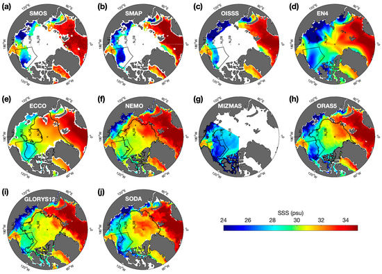
In spite of the importance of salinity and FWC to Arctic Ocean dynamics, making in situ observations in the area remains a challenge, and remote sensing, ocean modeling, and ocean reanalysis products are thus increasingly important to studying the region as they can fill in spatial and temporal gaps in measurements. Ocean models and reanalyses have been validated for parameters such as temperature, salinity, and sea-ice in the Arctic for a variety of time scales and regions [18,19,20,21], but there are still limitations in their abilities and usefulness. Satellite salinity and altimetry have been used as mechanisms to estimate FWC remotely [15,22,23,24], although there are also limitations to those datasets. Satellite salinity retrievals are restricted to ice-free regions and have large uncertainties in cold water, for example [25]. Evaluating our simulations of SSS and SSH will therefore allow us to assess FWC and its relationships to other parameters more accurately in the Arctic Ocean and improve predictions. It should also be noted that access to in situ measurements in areas such as the Russian shelf is very limited relative to measurements in west longitudes [26]. This emphasizes the importance of model simulations for the region, but to the extent they depend on climatology, wide variations among model results are expected.
In this paper, we present a multi-product analysis comparing salinity and related variables among in situ observations, satellite data, ocean model simulations, and reanalysis products to explore our understanding of FWC, its changes, and related variables. Focus is placed on the well-studied BG region, as well as on the change in long-term trends of FWC pre- and post-2007 due to the AO. With this paper, we aim to evaluate different ocean model products in the Arctic, especially when analyzing long-term trends. Our study covers January 1993–December 2021 depending on the availability of the products used. The products have varying spatial and temporal scales, as described in Section 2, along with our methods. Section 3 outlines the research results which are then discussed in Section 4. A conclusion is provided in Section 5.
......
5. Conclusions
The focus of this study was to compare both the FWC and drivers of freshwater, primarily SSS, SSH, and sea ice, between several ocean models and reanalysis products commonly used to analyze the Arctic Ocean. Most products represent previously defined BG characteristics, such as freshwater accumulation since the 1990s and the extension of the gyre to the northwest during that period, but the results of products outside the BG vary significantly. As satellite altimetry and salinity are used to estimate FWC where in situ observations are scarce, exploring our ability to predict relationships between these variables is a necessary step in furthering the study of FWC in the Arctic.Among the products compared, ORAS5 tended to be the most accurate at replicating EN4 FWC, and, in more recent years, SODA as well, due to the uniquely large salinity decrease at depth. ORAS5 also closely matches known ice dynamics in the BG, showing fresh surface waters following the sea-ice retreat in 2017. SODA uniquely represents river input on the Russian Shelf, which could be useful for questions of FWC and salinity in the Arctic as a whole but underestimates the sea-ice volume compared to other models, which could in part be due to this version’s different atmospheric reanalysis. ECCO’s correlation between FWC and SSH most closely matched those of EN4 and satellite DOT, likely related to the strong seasonal variability in FWV seen in the BG, although it also underestimates the sea-ice volume. NEMO overestimates salinity to the largest degree amongst the models compared here, and therefore underestimates FWC. MIZMAS has the largest underestimation of BG FWV, likely due to its maximum extending outside of the BG box. Long-term trends and products’ responses to observed changes in the Arctic Ocean attributed to the AO highlight the variability in model performance; however, with little consistency across much of the study. ORAS5, GLORYS12, and SODA showed potential to be useful tools for analyzing the AO and its interannual effects, showing changes in the FWC and SSH over time that correspond with the cyclonic mode of the Arctic Ocean. Some of the discrepancies in areas such as the Russian Shelf are likely due to a lack of in situ observations and can hopefully be improved with remote sensing observations moving forward.
Last edited:


