What's new

Have you looked at the North Pole lately?

igrowone

Well-known member
Veteran
time for a check on the earth's temperature
you know, the unfolding disaster mankind is ushering in
August was warm, very warm

August 2023​

The August global surface temperature was 1.25°C (2.25°F) above the 20th-century average of 15.6°C (60.1°F), making it the warmest August on record. This marked the first time an August temperature exceeded 1.0°C (1.8°F) above the long-term average. August 2023 was 0.29°C (0.52°F) warmer than the previous August record from 2016, but the anomaly was 0.10°C (0.18°F) lower than the all-time highest monthly temperature anomaly on record (March 2016). However, the August 2023 temperature anomaly was the third-highest anomaly of any month on record. August 2023 marked the 45th-consecutive August and the 534th-consecutive month with temperatures at least nominally above the 20th-century average.

1695255692239.gif

Powered by ZingChart
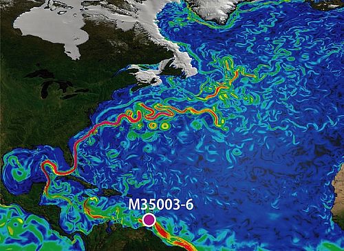
For the fifth consecutive month, global ocean surface temperature hit a record high. El Niño conditions that emerged in June continued into August, and NOAA's Climate Prediction Center issued a statement announcing a greater than 95% chance that El Niño will continue through the Northern Hemisphere winter. Globally, August 2023 set a record for the highest monthly sea surface temperature anomaly (+1.03°C or +1.85°F) of any month in NOAA's 174-year record.

Temperatures were above average throughout most of South America, Africa, Asia, North America, the Arctic and Oceania. Parts of southern North America, central South America, western and central Africa, central, southern, and eastern Asia, and northwestern and eastern Oceania experienced record-warm temperatures this month. Sea surface temperatures were above average across much of the northern, western, and southeastern Pacific, the Atlantic and the Indian Oceans. Record-warm temperatures covered nearly 13% of the world's surface this August, which was the highest August percentage since the start of records in 1951.

Temperatures were near to cooler than average across parts of the western and northeastern U.S., northeastern Russia and Antarctica. Sea surface temperatures were near to below average over parts of the southeastern and eastern tropical Pacific. Less than 1% of the world's surface had a record-cold August.

August 2023 Blended Land and Sea Surface Temperature Anomalies in degrees Celsius

August 2023 Blended Land and Sea Surface Temperature Percentiles

A smoothed map of blended land and sea surface temperature anomalies is also available.

North America, Asia, Africa, and South America each had their warmest August on record. South America had its highest monthly temperature anomaly of any month on record at +2.40°C (+4.32°F).

  • Peru had its warmest August on record.
  • August in Japan ranked warmest on record.
  • Hong Kong recorded its warmest August on record.
  • Turkey recorded its second-warmest August on record.
  • August in Israel ranked fifth warmest since records began in 1950.
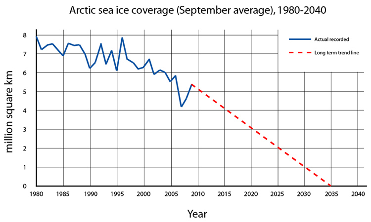
  • The Arctic had its warmest August on record.
  • The Caribbean region had its warmest August on record.
  • It was a record-warm August for the Gulf of Mexico.
  • August in the contiguous U.S. ranked ninth warmest on record.
Europe and Oceania each had their second-warmest August.

  • Spain tied 2003 for its warmest August on record, and the Spanish Peninsula and Balearic Islands sweltered under a heatwave for 16 days in August.
  • August in Portugal ranked fifth warmest on record.
  • Italy recorded its 14th-warmest August on record.
  • August in Switzerland ranked among the ten warmest on record.
  • August in Estonia was 1.3°C warmer than the long-term average.
  • Latvia had its 8th-warmest August on record.
  • Averaged as a country, Australia had its second-warmest August since records began in 1910.
  • Meanwhile, New Zealand had its coolest August in seven years.
 

igrowone

Well-known member
Veteran
so lets follow up here, we just had the all time hottest August
and before that? why it was the all time hottest July, quite the coincidence - no?
now here's the latest ice levels down south, quite the record indeed!
but from what I'm seeing it won't be a record low at the arctic, unless of course things take an unusual turn
S_iqr_timeseries.jpg
 

igrowone

Well-known member
Veteran

Antarctic sets a record low maximum by wide margin

September 25, 2023
On September 10, Antarctic sea ice likely reached its annual maximum extent of 16.96 million square kilometers (6.55 million square miles). This is the lowest sea ice maximum in the 1979 to 2023 sea ice record by a wide margin.
Please note that this is a preliminary announcement. Changing winds or late-season growth could still increase the Antarctic ice extent. NSIDC scientists will release a full analysis of the Antarctic and Arctic September conditions in early October.

Overview of conditions​

Antarctic sea ice extent on September 10, 2023
Figure 1. Antarctic sea ice extent for September 10 2023, was 16.96 million square kilometers (6.55 million square miles). The orange line shows the 1981 to 2010 average extent for that day. Sea Ice Index data. About the data

Credit: National Snow and Ice Data Center
High-resolution image
On September 10, 2023, sea ice in the Antarctic reached an annual maximum extent of 16.96 million square kilometers (6.55 million square miles), setting a record low maximum in the satellite record that began in 1979 (Figure 1). This year’s maximum is 1.03 million square kilometers (398,000 square miles) below the previous record low set in 1986. It is also 1.75 million square kilometers below (676,000 square miles) below the 1981 to 2010 average Antarctic maximum extent. Sea ice extent is markedly below average north of Queen Maud Land and west of the Antarctic Peninsula. Other low areas include the Indian Ocean and Ross Sea. Extent is above average stretching out of the Amundsen Sea.
The Antarctic maximum extent is one of the earliest on record, having reached it 13 days earlier than the 1981 to 2010 median date of September 23. The interquartile range for the date of the Antarctic maximum is September 18 to September 30.
 

igrowone

Well-known member
Veteran
The Sun sets on the Arctic melt season
October 4, 2023
A few days after the annual Arctic sea ice minimum extent was reached on September 19, the sun set at the North Pole, aiding sea ice growth. Arctic sea ice extent has grown at a fairly slow pace, leading to the fifth lowest September in the 45-year passive microwave satellite record. Antarctic sea ice extent has had an uptick in growth, but remains at record low levels for this time of year.
N_iqr_timeseries.jpg
asina_N_iqr_timeseries-9-375x300.jpg
 

trichrider

Kiss My Ring
Veteran

See SWOT Mission’s Unprecedented View of Global Sea Levels​


Oct. 30, 2023


Data on sea surface heights around the world from the international Surface Water and Ocean Topography mission yields a mesmerizing view of the planet’s ocean.


This animation shows global sea level data collected by the Surface Water and Ocean Topography satellite from July 26 to Aug. 16. Red and orange indicate higher-than-average ocean heights, while blue represents lower-than-average heights.
Credit: NASA/JPL-Caltech
The Surface Water and Ocean Topography (SWOT) satellite is sending down tantalizing views of Earth’s water, including a global composite of sea surface heights. The satellite collected the data visualized above during SWOT’s first full 21-day science orbit, which it completed between July 26 and Aug. 16.
SWOT is measuring the height of nearly all water on Earth’s surface, providing one of the most detailed, comprehensive views yet of the planet’s oceans and freshwater lakes and rivers. The satellite is a collaboration between NASA and the French space agency, CNES (Centre National d’Études Spatiales).
The animation shows sea surface height anomalies around the world: Red and orange indicate ocean heights that were higher than the global mean sea surface height, while blue represents heights lower than the mean. Sea level differences can highlight ocean currents, like the Gulf Stream coming off the U.S. East Coast or the Kuroshio current off the east coast of Japan. Sea surface height can also indicate regions of relatively warmer water – like the eastern part of the equatorial Pacific Ocean during an El Niño – because water expands as it warms.
The SWOT science team made the measurements using the groundbreaking Ka-band Radar Interferometer (KaRIn) instrument. With two antennas spread 33 feet (10 meters) apart on a boom, KaRIn produces a pair of data swaths (tracks visible in the animation) as it circles the globe, bouncing radar pulses off the water’s surface to collect surface-height measurements.

“The detail that SWOT is sending back on sea levels around the world is incredible,” said Parag Vaze, SWOT project manager at NASA’s Jet Propulsion Laboratory in Southern California. “The data will advance research into the effects of climate change and help communities around the world better prepare for a warming world.”

More About the Mission

Launched on Dec. 16, 2022, from Vandenberg Space Force Base in central California, SWOT is now in its operations phase, collecting data that will be used for research and other purposes.
SWOT was jointly developed by NASA and CNES, with contributions from CSA (Canadian Space Agency) and the UK Space Agency. JPL, which is managed for the agency by Caltech in Pasadena, California, leads the U.S. component of the project. For the flight system payload, NASA provided the KaRIn instrument, a GPS science receiver, a laser retroreflector, a two-beam microwave radiometer, and NASA instrument operations. CNES provided the Doppler Orbitography and Radioposition Integrated by Satellite (DORIS) system, the dual frequency Poseidon altimeter (developed by Thales Alenia Space), the KaRIn radio-frequency subsystem (together with Thales Alenia Space and with support from the UK Space Agency), the satellite platform, and ground operations. CSA provided the KaRIn high-power transmitter assembly. NASA provided the launch vehicle and the agency’s Launch Services Program, based at Kennedy Space Center, managed the associated launch services.
To learn more about SWOT, visit:
https://swot.jpl.nasa.gov/


trichrider

Kiss My Ring
Veteran

GEOMAR News


How salt from the Caribbean affects our climate​

Study explores link between salinity, ocean currents and climate​

03.11.2023/Kiel/Halifax/Bremerhaven/Bremen. Past cold periods such as the Little Ice Age were associated with reduced strength of North Atlantic currents and increased surface salinity in the Caribbean. This was accompanied by disturbances in the distribution of salt to the north leading to longer, stronger cooling phases in the northern hemisphere. Researchers from the Canadian Dalhousie University, GEOMAR Helmholtz Centre for Ocean Research Kiel, Alfred Wegener Institute, Helmholtz Centre for Polar and Marine Research and MARUM - Center for Marine Environmental Sciences at the University of Bremen have proven this connection. They have now published their research results in the journal Science Advances. The study supports the hypothesis that salt transfer through ocean currents is a crucial regulator of global climate.
Joint press release by MARUM - Center for Marine Environmental Sciences at the University of Bremen and GEOMAR Helmholtz Centre for Ocean Research Kiel
The distribution of salt by ocean currents plays a crucial role in regulating the global climate. This is what researchers from Dalhousie University in Canada, GEOMAR Helmholtz Centre for Ocean Research Kiel, Alfred Wegener Institute, Helmholtz Centre for Polar and Marine Research (AWI) and MARUM – Center for Marine Environmental Sciences at the University of Bremen have found in a new study. They studied natural climate anomalies, including the so-called Little Ice Age. This cold period from the 15th to the mid-19th century led to poor harvests, famine and disease in Europe. Although the Little Ice Age is one of the most studied periods in recent history, the underlying climatic mechanisms remain controversial.
“Looking at recent, natural climate anomalies helps to understand the processes and mechanisms that human-induced global warming may trigger,” says Dr Anastasia Zhuravleva, lead author of the study. She was a PhD student at GEOMAR and received the Annette Barthelt Prize for her dissertation in 2019. She then worked as a post-doctoral researcher at GEOMAR and Dalhousie University, where the study was completed.
“Researchers often consider an increase in sea ice extent and desalination in the subpolar North Atlantic as possible triggers for past cold periods, but processes in the tropical Atlantic appear to be equally important," says Dr Zhuravleva. “In fact, in contrast to the northern and mid-latitudes, there is little information on these recent climate events from the subtropical-tropical Atlantic and their impact on regions in the Northern Hemisphere,” adds Dr Henning Bauch, paleoclimatologist at AWI and GEOMAR, co-initiator and co-author of the study. “This is where our research comes in.”
So, what happened in the tropical Atlantic during historical climate anomalies, and how might potential changes there have affected ocean circulation and climate much further north? To answer these questions, the team worked on a sediment profile from the southern Caribbean and reconstructed the salinity and temperature of the surface water over the last 1700 years. Among other things, the researchers determined the isotopic and elemental composition of the calcareous shells of plankton.
The results show a cooling of about 1°C during the Little Ice Age. “It is a significant temperature change for this region,” says Dr Mahyar Mohtadi, co-author of the study and head of the Low Latitude Climate Variability group at MARUM. “Particularly noteworthy is the occurrence of another pronounced cooling for the 8th-9th centuries. Colder temperatures in the otherwise warm tropical ocean led to lower regional rainfall, which coincided with severe droughts in the Yucatan Peninsula and the decline of the Classic Maya culture.”
In addition, the researchers found that the cold climate anomalies in the subpolar North Atlantic and Europe were accompanied by weaker ocean circulation and increased salinity in the Caribbean. “Advection, or the movement of tropical salt to high northern latitudes, is essential for maintaining high surface densities in the subpolar North Atlantic. This is a prerequisite for the overall stability of the large-scale ocean circulation, including the transfer of warm Gulf Stream water, which is responsible for our mild temperatures in Europe,” says Dr Bauch.
The data on the historical past thus allow a reconstruction of the connection across the North Atlantic. Initial cooling can be caused by volcanic eruptions, low solar activity and feedbacks between sea ice and the ocean in the north. The new study provides evidence that a decrease in salt movement to high northern latitudes will amplify and prolong these climate events. Conversely, the slow movement of positive salinity anomalies from the tropics will eventually increase the density at the surface of the subpolar North Atlantic. This may favour the northward transport of heat by ocean currents, resulting in milder temperatures over Europe and North America.
“Such a salinity feedback is known from models and has been assumed for the Little Ice Age. However, in the absence of tropical ocean data, these assumptions have been based on less direct precipitation records,” says Dr Zhuravleva.
There is evidence that the Gulf Stream is weakening and that human-induced warming is a likely cause. What is certain is that the consequences of this change will be global. The extent to which the different climate mechanisms interact has been an open question. This study now confirms that the south-north transport of salt is a key factor in the processes involved.
 

igrowone

Well-known member
Veteran
time to show the September record, this will lead in well with the next records that will be piling up this winter

September 2023
The September global surface temperature was 1.44°C (2.59°F) above the 20th-century average of 15.0°C (59.0°F), making it the warmest September on record. September 2023 marked the 49th-consecutive September and the 535th-consecutive month with temperatures at least nominally above the 20th-century average. September 2023 was 0.46°C (0.83°F) above the previous record from September 2020, and marks the largest positive monthly global temperature anomaly of any month on record. The September 2023 global temperature anomaly surpassed the previous record-high monthly anomaly from March 2016 by 0.09°C (0.16°F). The past ten Septembers (2014–2023) have been the warmest Septembers on record.

1699660536341.png

For the sixth consecutive month, September saw a record-high monthly global ocean surface temperature. September 2023 tied August 2023 for the highest monthly sea surface temperature anomaly (+1.03°C or +1.85°F) of any month in NOAA's 174-year record. El Niño conditions that emerged in June continued into September, and according to NOAA's Climate Prediction Center there is a greater than 95% chance that El Niño will continue through the Northern Hemisphere winter (January–March 2024).

Temperatures were above average throughout most of North America, South America, Europe, Africa, Asia, Oceania and Antarctica. Parts of Europe, southern and north-central North America, northern and central South America, western and eastern Africa, southwestern and central eastern Asia, southwestern Oceania and Antarctica experienced record-warm temperatures this month. Sea surface temperatures were above average across much of the northern, western and southwestern Pacific as well as the Atlantic and the Indian Ocean. Record-warm temperatures covered 20% of the world's surface this September, which was the highest percentage of any month since the start of records in 1951.

Temperatures were near to cooler than average across parts of southern South America and central Russia. Sea surface temperatures were near to below average over parts of the southeastern Pacific Ocean. Less than 1% of the world's surface had a record-cold September.


North America, South America, Africa, and Europe each had their warmest September on record. South America had a September that was 2.48°C (4.46°F) above the 20th century average, which was its highest monthly temperature departure from average of any month on record.

The contiguous U.S. had its seventh-warmest September in the 129-year record. More than 100 U.S. counties had their warmest September on record.
September in Peru ranked warmest on record.
Denmark had its warmest September on record, and in an unusual occurrence, September was actually warmer than both July and August.
Austria had its warmest September in the 257-year record.
Switzerland recorded its warmest September on record.
September in Germany also ranked warmest on record.
Latvia also had its warmest September on record.
At 2.2°C above the 1991–2020 average, September 2023 in the United Kingdom tied September 2006 as the warmest on record. England and Wales each had their warmest September on record.
The Netherlands had its second-warmest September since 1901.
Italy had its third-warmest September on record.
Asia had its second-warmest September.

September in Japan ranked warmest on record.
Hong Kong experienced 10 consecutive "very hot days", the longest streak of such weather in the region during September.
Pakistan had its fourth-warmest September on record.
September in Turkey ranked sixth warmest on record.
September in Oceania ranked third warmest on record.

New Zealand recorded its warmest September on record at 1.3°C above average.
It was Australia's driest and third-warmest September on record.
 
Last edited:

Rgd

Well-known member
Veteran
Their main food is seal meat. They catch them buy standing above breathing holes on the ice. No Ice = No Seal Meat.
what did they and the polar bears do
when there were
green fields in Greenland?

the earth does what it wants when it wants

we do however create a good bunch of pollution

we are giving away our freedom to fix fake climate change scenerios
while our masters jet around
 

Charles Dankens

Well-known member
it certainly is a fabrication that it is caused by human burning of fossil fuels, that is the conspiracy.
you cannot claim high ground with a cartoon from nasa.
cycles will reveal themselves as they turn over.
this is the end of ice melt for the year and the growth will begin now.
happens all the time.
A Trumper's concept of scholarly rigor! As ludicrous, misguided and irrelevant as Trump's failing explanations for fraud² and sexual assault.


Jolly at the North Pole
PSX_20231017_211512.jpg
 

Attachments

  • PSX_20231017_211512.jpg
    PSX_20231017_211512.jpg
    231.3 KB · Views: 15

igrowone

Well-known member
Veteran
3rd record monthly temperature in a row, but who's counting?

October 2023​

The October global surface temperature was 1.34°C (2.41°F) above the 20th-century average of 14.0°C (57.1°F), making it the warmest October on record. This was 0.24°C (0.43°F) above the previous record from October 2015. October 2023 marked the 47th-consecutive October and the 536th-consecutive month with temperatures at least nominally above the 20th-century average. The past 10 Octobers (2014–2023) have been the warmest Octobers on record.

1701477691320.gif


October saw a record-high monthly global ocean surface temperature for the seventh consecutive month. El Niño conditions that emerged in June continued into October, and according to NOAA's Climate Prediction Center there is an 80% chance that El Niño will continue through the Northern Hemisphere spring (March–May 2024).

Temperatures were above average throughout most of North America, South America, western, southern, and eastern Europe, Africa, Asia, Oceania and the Arctic. Parts of Central and South America, Africa, Europe, northeastern North America and central Asia experienced record-warm temperatures this month. Sea surface temperatures were above average across much of the northern, western and eastern Pacific as well as the northern Atlantic and the Indian Oceans. Record-warm temperatures covered nearly 11% of the world's surface this October, which was the highest percentage for October since the start of records in 1951.

Temperatures were near to cooler than average across parts of Antarctica, southern South America, north-central North America, the Nordic countries, Greenland and northern Oceania. Sea surface temperatures were near to below average over parts of the southeastern Pacific Ocean, the eastern Indian Ocean and the southern Atlantic Ocean. Less than 1% of the world's surface had a record-cold October.

The Northern Hemisphere had its warmest October on record at 1.92°C (3.46°F) above average. Both land and ocean temperatures were at record-highs for the Northern Hemisphere this October. Meanwhile, the Southern Hemisphere had its third-warmest October on record at 0.77°C (1.39°F) above average. Only the Octobers of 2015 and 2018 had a higher average temperature in the Southern Hemisphere. However, the average ocean-only temperature for October in the Southern Hemisphere ranked warmest on record this October, while the land-only temperature ranked 15th warmest on record for the month.

October 2023 Blended Land and Sea Surface Temperature Anomalies in degrees Celsius
October 2023 Blended Land and Sea Surface Temperature Percentiles
October 2023 Blended Land and Sea Surface Temperature
 

GenghisKush

Well-known member
Tric, you're a scientist, yes? Or at least you're someone who is curious about science (I think that makes one a scientist, but that's just me).

Have you ever tested the greenhouse effect for yourself? Have you done the experiment?

Can you reproduce this result in your home lab?

 
Top